|
FA1997.102:-
|
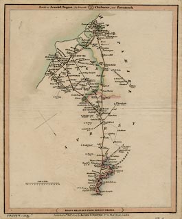
Road map, scale about 7 miles to 1 inch, London to Arundel, Chichester, etc
West Sussex and to Portsmouth etc, Hampshire, from a road book by Laurie and
Whittle, 53 Fleet Street, London, 1806.
|
|
Pl.3 London; Kingston on Thames, Guildford, Godalming, and Haslemere, Surrey;
Petworth, Arundel, Bognor, Midhurst, and Chichester, West Sussex; Petersfield,
Horndean, Havant, Fareham, Portsmouth and Gosport, Hampshire.
|
|
inscription:- |
printed -on- top of map
Roads to Arundel, Bognor, (by Petworth) 3 Chichester, and Portsmouth
|
|
inscription:- |
printed -on- bottom of map
ROADS MEASURED FROM LONDON BRIDGE
|
|
inscription:- |
printed -on- below map
Published 12th. Feby. 1806, by LAURIE & WHITTLE, No. 53, Fleet Street,
London
|
|
inscription:- |
printed -on- bottom right
B. Smith sc.
|
|
map feature:-
|
compass rose (simple cross with fleur de lys for N) & scale line & roads
& rivers & settlements & road distances & county |
|
dimension:- |
wxh = 26.5x32cm |
|
scale = 1 to 470000 ? (465512 approx) |
 |
|

|
Map Group -- Laurie and Whittle 1806 -- with Research Notes
|
 |
|
|
town names:-
|
|
Hampshire
|
Hampshire
|
|
map name
|
modern name
|
|
Alton
|
Alton
|
|
Fareham
|
Fareham
|
|
Gosport
|
Gosport
|
|
Havant
|
Havant
|
|
Petersfield
|
Petersfield
|
|
Portsmouth
|
Portsmouth
|
|
 |
|

| top of page |
| MN: 4.10.2001 |


