|
FA1998.1:-
|
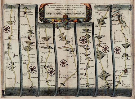
Strip map, hand coloured copper plate engraving, road map, part of The Road
From London to Weymouth, scale about 1 inch to 1 mile, from the road book,
Britannia, published by John Ogilby, White Friars, London, 1675.
|
|
Pl.53 from Basingstoke to Sutton Scotney, Stockbridge, Broughton, Hampshire,
into Wiltshire at West Dean, via Dunkerton, across Dorset through Cranborne,
Wimborne Minster, Blandford Forum, Dorchester, to Weymouth.
|
|
inscription:- |
printed -on- title cartouche
The Road From LONDON to WEYMOUTH com. DORSET. / By IOHN OGILBY Esqr. His
Maties. Cosmographer.
-- fruit |
|
map feature:-
|
hand coloured & title cartouche & roads & road distances &
rivers & compass rose & coat of arms (royal) & settlements &
streets & woods & trees & relief & hillocks & county &
coast shaded & harbours & ducking stools & windmills |
|
dimension:- |
wxh, sheet = 50.5x38cm |
|
scale = 1 to 63360 ? (nominal) |
 |
|
|
reference:- |
Ogilby, John: 1675: Britannia; A Geographical and Historical Description of the
Principal Roads thereof |

|
Map Group -- Ogilby 1675 -- with Research Notes
|
 |
|
|
town names:-
|
|
Hampshire
|
Hampshire
|
|
map name
|
modern name
|
|
Basingstoke
|
Basingstoke
|
|
Stockbridge
|
Stockbridge
|
|
 |
|

| top of page |
| MN: 4.10.2001 |


