|
FA1998.3:-
|
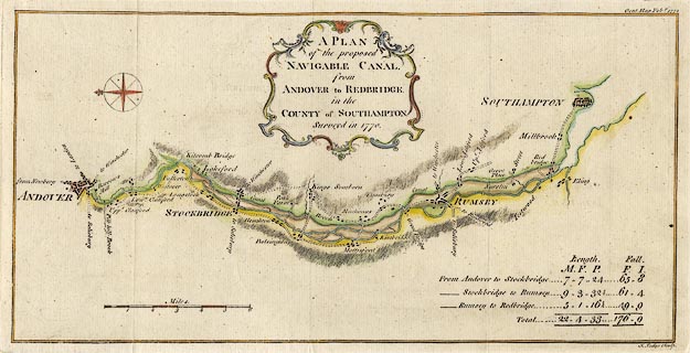
Map, the proposed Navigable Canal from Andover to Redbridge, Hampshire, scale
about 2 miles to 1 inch, engraved by J Lodge, surveyed 1770, published in the
Gentleman's Magazine, February 1772.
|
|
Canal or river navigation running beside the River Anton and River Test, from
Andover, via or near Stockbridge, Kings Somborne, Romsey to Redbridge,
Southampton, Hampshire.
|
|
map feature:-
|
compass rose (simple, fleur de lys marks north) & scale line & relief
& canals & rivers & bridges & settlements & title cartouche
& table of distances |
|
inscription:- |
printed -on- map
A PLAN / of the proposed / NAVIGABLE CANAL, / from / ANDOVER to REDBRIDGE. /
in the / COUNTY of SOUTHAMPTON. / Surveyed in 1770.
-- title cartouche |
|
inscription:- |
printed -on- bottom right
J. Lodge Sculp.
|
|
inscription:- |
printed -on- top right
Gent. Mag. Feby. 1772
|
|
scale line:-
|
6 miles = 75.0 mm |
|
dimension:- |
wxh, sheet = 37x19.5cm |
|
wxh, plate = 355x180mm (?) |
|
wxh, map = 343x168mm |
|
scale = 1 to 130000 ? (1 to 128748 from scale line assuming modern mile) |
 |
|

|
Map Group -- Gent Mag 1770s -- with Research Notes
|
 |
|
|
town names:-
|
|
County of Southampton
|
Hampshire
|
|
map name
|
modern name
|
|
Andover
|
Andover
|
|
Rumsey
|
Romsey
|
|
Southampton
|
Southampton
|
|
Stockbridge
|
Stockbridge
|
|
 |
|

| top of page |
| MN: 4.10.2001 |


