|
FA1998.128:-
|
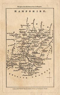
Map, uncoloured engraving, Hampshire, and the Isle of Wight, scale about 18.5
miles to 1 inch, from the Family Topographer by Samuel Tymms, published by J B
Nichols and Son, 25 Parliament Street, London, 1832.
|
|
map feature:-
|
not coloured & north point & coast form lines & rivers & parks
(some shaded areas?) & county & settlements & roads & road
distances (from Southampton) |
|
inscription:- |
printed -on-
HAMPSHIRE
|
|
inscription:- |
printed -on- bottom centre
London. Pubd. Feby. 1st. 1832, by Nichols & Son, 25 Parliament Street.
|
|
dimension:- |
wxh, sheet = 10.5x17cm |
|
wxh, plate = 88x142mm |
|
wxh, map = 77x125mm |
|
scale = 1 to 1200000 ? (1 to 1185895 estimated from two town-town distances
using DISTTAB.exe) |
|
scale = 1 to 1200000 ? (from town positions using DISTAB.exe) |
 |
|
|
reference:- |
Tymms, Samuel: 1832: Family Topographer, The |

|
Map Group -- Tymms 1832 -- with Research Notes
|
 |
|
|
town names:-
|
|
Hampshire
|
Hampshire
|
|
map name
|
modern name
|
|
Alton
|
Alton
|
|
Andover
|
Andover
|
|
Basingstoke
|
Basingstoke
|
|
Bishops Waltham
|
Bishops Waltham
|
|
Christ Church
|
Christchurch
|
|
Fareham
|
Fareham
|
|
Fordingbridge
|
Fordingbridge
|
|
Gosport
|
Gosport
|
|
Havant
|
Havant
|
|
Kingsclere
|
Kingsclere
|
|
Lymington
|
Lymington
|
|
Alresford
|
Alresford
|
|
Odiham
|
Odiham
|
|
Petersfield
|
Petersfield
|
|
Portsmouth
|
Portsmouth
|
|
Ringwood
|
Ringwood
|
|
Romsey
|
Romsey
|
|
Southampton
|
Southampton
|
|
Stockbridge
|
Stockbridge
|
|
Whitchurch
|
Whitchurch
|
|
Winchester
|
Winchester
|
|
 |
|

| top of page |
| MN: 4.10.2001 |


