|
FA1998.129:-
|
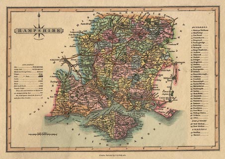
Map, hand coloured engraving, Hampshire, and the Isle of Wight, scale about 8.5
miles to 1 inch, engraved by James Wallis, published by S A Oddy, London,
1812.
|
|
map feature:-
|
hand coloured & title cartouche (shaded box, overlaying compass rose) &
compass rose (cardinal and half cardinal points, but partly obscured, fleur de
lys for north) & scale line (12 miles, chequered) & lat and long scales
(notice the wrong '0' where it should be '2' degrees) & sea shaded &
coast shaded & rivers & relief & hill hachuring & parks &
county & hundreds & settlements (graded by lettering and amount of
buildings) & roads & turnpike roads & post roads & table of
symbols & canals & distances from London |
|
inscription:- |
printed -on- title cartouche
HAMPSHIRE
|
|
inscription:- |
printed -on- bottom centre
London Publish'd by S. A. Oddy, 1812.
|
|
inscription:- |
printed -on- below compass rose
Engrav'd by J. Wallis.
|
|
scale line:-
|
12 miles = 34.8 mm |
|
dimension:- |
scale = 1 to 550000 ? (1 to 554946 from scale line assuming modern mile) |
|
scale = 1 to 580000 ? (45 min = 145mm on latitude scale is 1 to 575784) |
|
wxh, sheet = 29.5x20.5cm |
|
wxh, map = 267x177mm |
|
longitude, Winchester = 1d 17.5m W (approx) |
 |
|

|
Map Group -- Wallis 1812 -- with Research Notes
|
 |
|
|
town names:-
|
|
Hampshire
|
Hampshire
|
|
map name
|
modern name
|
|
Alton
|
Alton
|
|
Andover
|
Andover
|
|
Basingstoke
|
Basingstoke
|
|
Bishops Waltham
|
Bishops Waltham
|
|
Christ Church
|
Christchurch
|
|
Fareham
|
Fareham
|
|
Fordingbridge
|
Fordingbridge
|
|
Gosport
|
Gosport
|
|
Havant
|
Havant
|
|
Kingsclere
|
Kingsclere
|
|
Lymington
|
Lymington
|
|
New Alresford
|
Alresford
|
|
Odiham
|
Odiham
|
|
Petersfield
|
Petersfield
|
|
Portsmouth
|
Portsmouth
|
|
Ringwood
|
Ringwood
|
|
Romsey
|
Romsey
|
|
Southampton
|
Southampton
|
|
Stockbridge
|
Stockbridge
|
|
Whitchurch
|
Whitchurch
|
|
Winchester
|
Winchester
|
|
 |
|

| top of page |
| MN: 4.10.2001 |


