|
FA1998.159:-
|
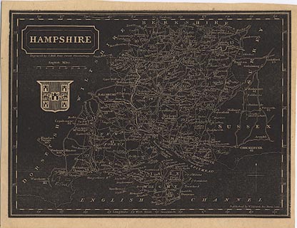
Map, white on black print, Hampshire, with the Isle of Wight, scale about 10
miles to 1 inch, by S Hall, Bury Street, Bloomsbury, published, probably in
Pinnock's Guide to Knowledge, by W Edwards, Ave Maria Lane, London, about
1833.
|
|
map feature:-
|
not coloured & north point & scale line & lat and long scales &
county & hundreds (?) & rivers & canals & parks &
settlements & roads & coat of arms (Winchester) |
|
inscription:- |
-on- upper left
HAMPSHIRE / Engraved by S. Hall Bury Street Bloomsbury.
|
|
inscription:- |
-on- lower right
Published by W. Edwards, Ave Maria Lane.
|
|
scale line:-
|
16 miles = 41.3 mm |
|
dimension:- |
scale = 1 to 620000 ? (1 to 623475 from scale line assuming modern mile) |
|
longitude, Winchester = 1d 18.9m W (approx) |
 |
|
|
reference:- |
Pinnock: 1835 (?): Guide to Knowledge: Edwards, W (London) |

|
Map Group -- Pinnock 1833 -- with Research Notes
|
 |
|
|
town names:-
|
|
Hampshire
|
Hampshire
|
|
map name
|
modern name
|
|
Alton
|
Alton
|
|
Andover
|
Andover
|
|
Basingstoke
|
Basingstoke
|
|
Bishops Waltham
|
Bishops Waltham
|
|
Christchurch
|
Christchurch
|
|
Fareham
|
Fareham
|
|
Fordingbridge
|
Fordingbridge
|
|
Gosport
|
Gosport
|
|
Havant
|
Havant
|
|
Kingsclere
|
Kingsclere
|
|
Lymington
|
Lymington
|
|
New Alresford
|
Alresford
|
|
Odiham
|
Odiham
|
|
Petersfield
|
Petersfield
|
|
Portsmouth
|
Portsmouth
|
|
Ringwood
|
Ringwood
|
|
Romsey
|
Romsey
|
|
Southampton
|
Southampton
|
|
Stockbridge
|
Stockbridge
|
|
Whitchurch
|
Whitchurch
|
|
Winchester
|
Winchester
|
|
 |
|

| top of page |
| MN: 10.3.2003 |


