|
FA1998.165:-
|
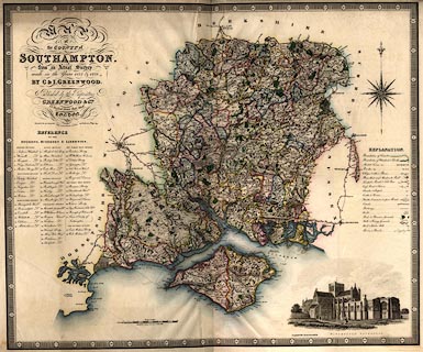
Map, hand coloured engraving, Map of the County of Southampton, ie Hampshire,
with the Isle of Wight, scale about 3 miles to 1 inch, by C and J Greenwood,
engraved by J and J Neele, Strand, London, published by Greenwood and Co, 13
Regent Street, London, 1829.
|
|
The map is reduced from their larger map at the scale 1 mile to 1 inch which
was published 1826.
|
|
map feature:-
|
hand coloured & compass rose & table of symbols & coast form lines
& rivers & relief & hill hachuring & woods & forests &
parks & vignettes (Winchester Cathedral) & county & hundreds &
table of hundreds (and divisions and liberties) & divisions &
settlements & roads & canals & electoral data |
|
inscription:- |
-on-
MAP / of / the COUNTY of / SOUTHAMPTON / from an Actual Survey / made in the
Years 1825 and 1826 / By C & I. GREENWOOD / Published by the Proprietors /
GREENWOOD & Co. / 13, Regent Street, Pall Mall, / LONDON / Corrected to the
present period and Published 4th. July 1829. / Engraved by J. & J. Neele 352
Strand
|
|
scale line:-
|
10 miles = 81.8 mm |
|
dimension:- |
scale = 1 to 200000 ? (1 to 196741 from scale line assuming modern mile) |
|
scale = 1 to 190000 ? (from town positions using DISTAB.exe) |
|
longitude, Winchester = 1d 18.5m W (approx) |
 |
|
|
reference:- |
Greenwood, C & J: 1834: Atlas of the Counties of England
Chubb names C and J as Charles and John; Tooley gives Charles and
James; Rodger states Christopher and John; none give reasons.
|

|
Map Group -- Greenwood 1829
|
 |
|
|
town names:-
|
|
County of Southampton
|
Hampshire
|
|
map name
|
modern name
|
|
Alton
|
Alton
|
|
Andover
|
Andover
|
|
Basingstoke
|
Basingstoke
|
|
Bishops Waltham
|
Bishops Waltham
|
|
Christ Church
|
Christchurch
|
|
Fareham
|
Fareham
|
|
Fordingbridge
|
Fordingbridge
|
|
Gosport
|
Gosport
|
|
Havant
|
Havant
|
|
Kingsclere
|
Kingsclere
|
|
Lymington
|
Lymington
|
|
New Alresford
|
Alresford
|
|
Odiham
|
Odiham
|
|
Petersfield
|
Petersfield
|
|
Portsmouth
|
Portsmouth
|
|
Ringwood
|
Ringwood
|
|
Romsey
|
Romsey
|
|
Southampton
|
Southampton
|
|
Stockbridge
|
Stockbridge
|
|
Whitchurch
|
Whitchurch
|
|
Winchester
|
Winchester
|
|
 |
|

| top of page |
| MN: 4.10.2001 |


