|
FA1998.205:-
|
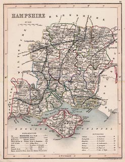
Map, uncoloured engraving, Hampshire, with the Isle of Wight, scale about 8
miles to 1 inch, drawn by J Archer, Pentonville, London, published in England
and Wales Delineated by T Dugdale, about 1835, published 1860s-70s?
|
|
Page or plate 16.
|
|
This edition of the map has the London and South Western Railway, LSWR, entering
the county at Farnborough, Rushmoor, via Basingstoke, Winchester to Southampton,
and branches to Andover and into Wiltshire towards Salisbury, to Fareham and
Gosport, to Havant, Portsmouth and to Chichester in West Sussex, to Romsey and
into Wiltshire towards Salisbury, across the New Forest to Ringwood and into
Dorset, from Reading in Berkshire to Basingstoke, from Haslemere in Surrey to
Havant and Portsmouth, into the county near Aldershot, Rushmoor to Alton, from
Romsey to Redbridge, from Andover via Stockbridge to Mottisfont junction, from
Brockenhurst to Lymington.
|
|
The London Portsmouth line's route is uncorrected.
|
|
map feature:-
|
not coloured & scale line (10 miles, chequered) & lat and long scales
& sea shaded & coast shaded & rivers & relief & hill
hachuring & trees & forests & woods & parks & county &
electoral data & divisions & settlements (graded by lettering) &
roads & turnpike roads & canals & railways & table of
symbols |
|
inscription:- |
printed -on- upper left
HAMPSHIRE
|
|
inscription:- |
printed -on- bottom
Drawn & Engraved by J. Archer Pentonville London.
|
|
scale line:-
|
10 miles = 30.1 mm |
|
dimension:- |
scale = 1 to 530000 ? (1 to 534666 from scale line assuming modern mile) |
|
scale = 1 to 570000 ? (1 deg = 195.1mm on latitude scale is 1 to 570571) |
|
wxh, sheet = 22x26cm |
|
wxh, map = 179x234mm |
 |
|
|
reference:- |
Dugdale, T: 1848 (or later): Curiosities of Great Britain:: includes 58 maps by
J Archer; p81 |
|
Dugdale, T:: England and Wales Delineated |

|
Map Group -- Dugdale 1835 -- with Research Notes
|
 |
|

| top of page |
| MN: 4.10.2001 |


