|
FA1998.216:-
|
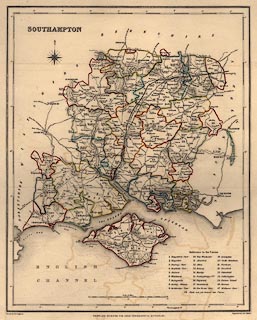
Map, Southampton, ie Hampshire, scale about 7 miles to 1 inch, drawn by R
Creighton, 1831, engraved by J and C Walker, for the Topographical Dictionary
published by Lewis, London? edition of 1840s?
|
|
The Poor Law unions are indicated and listed in a table.
|
|
The railways, London to Southampton, plus the branch to Gosport date the map to
late 1840s.
|
|
inscription:- |
printed -on- upper left
SOUTHAMPTON
|
|
inscription:- |
printed -on- bottom
Drawn by R. Creighton / DRAWN AND ENGRAVED FOR LEWIS' TOPOGRAPHICAL
DICTIONARY. / Engraved by J&C Walker.
|
|
map feature:-
|
compass rose & scale line & lat and long scales & coast form lines
& county & roads & settlements & relief & hill hachuring
& rivers & electoral data & harbours & table of unions &
canals |
|
dimension:- |
wxh = 27x33cm |
|
scale = 1 to 430000 ? (approx, 1 to 426316 ?) |
|
longitude, Winchester = 1d 17.4m W (approx) |
 |
|

|
Map Group -- Lewis 1831 -- with Research Notes
|
 |
|
|
town names:-
|
|
Southampton
|
Hampshire
|
|
map name
|
modern name
|
|
Alton
|
Alton
|
|
Andover
|
Andover
|
|
Basingstoke
|
Basingstoke
|
|
Bishops Waltham
|
Bishops Waltham
|
|
Christchurch
|
Christchurch
|
|
Fareham
|
Fareham
|
|
Fordingbridge
|
Fordingbridge
|
|
Gosport
|
Gosport
|
|
Havant
|
Havant
|
|
Kingsclere
|
Kingsclere
|
|
Lymington
|
Lymington
|
|
New Alresford
|
Alresford
|
|
Odiham
|
Odiham
|
|
Petersfield
|
Petersfield
|
|
Portsmouth
|
Portsmouth
|
|
Ringwood
|
Ringwood
|
|
Romsey
|
Romsey
|
|
Southampton
|
Southampton
|
|
Stockbridge
|
Stockbridge
|
|
Whitchurch
|
Whitchurch
|
|
Winchester
|
Winchester
|
|
 |
|

| top of page |
| MN: 4.10.2001 |


