|
FA1998.219:-
|
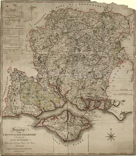
Map, hand coloured engraving, Hampshire or the County of Southampton, scale
about 2.5 miles to 1 inch, published by William Faden, Charing Cross, London,
1796.
|
|
Reduced from the large map in six sheets by Milne, published by Faden, 1791.
|
|
Tables of information about Basingstoke Canal and Andover Canal and about
Woolmer Forest and Alice Holt Forest.
|
|
map feature:-
|
hand coloured & compass rose (Prince of Wales feathers for N) & scale
line & lat and long scales & time from Greenwich & coast form lines
& rivers & relief & hill hachuring & woods & forests &
parks & county & hundreds & settlements & roads &
canals |
|
inscription:- |
printed -on- lower left
Hampshire / or the / COUNTY of SOUTHAMPTON / Including the / ISLE OF WIGHT /
Reduced from the large Map in Six Sheets / BY W. FADEN / Geographer to His
Majesty, and to H.R.H. the Prince of Wales / Charing Cross June 4th. 1796.
|
|
scale line:-
|
6 miles = 60.2 mm |
|
dimension:- |
wxh, map = 567x653mm |
|
scale = 1 to 160000 ? (1 to 156194 from town positions using DISTTAB.exe) |
|
longitude, Winchester = 1d 18.3m W (approx) |
 |
|

|
Map Group -- Faden 1796 -- with Research Notes
|
 |
|
|
town names:-
|
|
County of Southampton
|
Hampshire
|
|
map name
|
modern name
|
|
Alton
|
Alton
|
|
Andover
|
Andover
|
|
Basingstoke
|
Basingstoke
|
|
Bishops Waltham
|
Bishops Waltham
|
|
Christchurch
|
Christchurch
|
|
Fareham
|
Fareham
|
|
Fordingbridge
|
Fordingbridge
|
|
Gosport
|
Gosport
|
|
Havant
|
Havant
|
|
Kingsclere
|
Kingsclere
|
|
Lymington
|
Lymington
|
|
Alresford
|
Alresford
|
|
Odiham
|
Odiham
|
|
Petersfield
|
Petersfield
|
|
Portsmouth
|
Portsmouth
|
|
Ringwood
|
Ringwood
|
|
Romsey
|
Romsey
|
|
Southampton
|
Southampton
|
|
Stockbridge
|
Stockbridge
|
|
Whitchurch
|
Whitchurch
|
|
Winchester
|
Winchester
|
|
 |
|

| top of page |
| MN: 15.11.2001 |


