|
FA1998.149:-
|
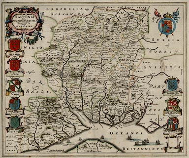
Map, hand coloured engraving, Hampshire or the County of Southampton, or
Hantshire, scale about 3.5 miles to 1 inch, published in Theatrum Orbis
Terrarum, by William J Blaeu, Amsterdam, Netherlands, 1645.
|
|
The Old English Mile used by the map maker is 1.26 statute miles.
|
|
map feature:-
|
hand coloured & coat of arms (royal and noble) & ships & scale line
& coast shaded & rivers & relief & hillocks & trees &
woods & forests & county & hundreds & settlements |
|
scale line:-
|
4 miles = 36.7 mm |
|
inscription:- |
printed -on- title cartouche
HANTONIA / SIVE / SOUTHANTONENSIS / COMITATUS / Vulgo / HANT-SHIRE
|
|
inscription:- |
printed -on-
Cliton a Saxon Earle of Wincester / Saer Quincy Earle of Wincester / Hugh
Spencer Earle of Wincester / Ludowick Bruget Earle of Wincester / William Paulet
Marques of Wincester / Bogo or Beavous Earle of Southamton a famous warrier
against ye Normans / William Fitz William Earl of Southampton by Kinge Henry 8 /
Tho Wriotheosley created Earle of Southampton by Kinge Edward 6 Anno 1
-- captions to noble coats of arms |
|
dimension:- |
wxh, plate = 516x420mm |
|
scale = 1 to 220000 ? (from town positions using DISTAB.exe) |
 |
|

|
Map Group -- Blaeu 1645 -- with Research Notes
|
 |
|
|
town names:-
|
|
Hantshire
|
Hampshire
|
|
map name
|
modern name
|
|
Alton
|
Alton
|
|
Andover
|
Andover
|
|
Basingstoke
|
Basingstoke
|
|
Bushwaltham
|
Bishops Waltham
|
|
Christ church
|
Christchurch
|
|
Farham
|
Fareham
|
|
Fording bridge
|
Fordingbridge
|
|
Gosporte
|
Gosport
|
|
Havant
|
Havant
|
|
Kingscler
|
Kingsclere
|
|
Lymington
|
Lymington
|
|
Alresford
|
Alresford
|
|
Odiam
|
Odiham
|
|
Petersfeild
|
Petersfield
|
|
Portesmouth
|
Portsmouth
|
|
Ringwood
|
Ringwood
|
|
Rumsey
|
Romsey
|
|
Southampton
|
Southampton
|
|
Stokbridg
|
Stockbridge
|
|
Whitchurch
|
Whitchurch
|
|
Winchester
|
Winchester
|
|
 |
|

| top of page |
| MN: 6.2.2002 |


