|
FA1998.289:-
|
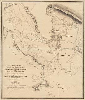
Chart, uncoloured engraving, map of part of the Coast of Hampshire from
Portsmouth to Southampton Water, and the opposing part of the Isle of Wight,
scale about 2 inches to 1 mile, by Captain John Knight RN, published by William
Faden, Charing Cross, London, 1799.
|
|
The fortifications of Portsmouth and Gosport, Hampshire and clearly marked, with
a magazine at Gosport.
|
|
map feature:-
|
not coloured & north point & magnetic variation & depth soundings
& buoys & sandbanks & anchorages & leading lines & rivers
& harbours & rivers & relief & hill hachuring &
fortifications & telegraphs & castles |
|
inscription:- |
printed -on- title
CHART OF THE / COAST OF HAMPSHIRE / from / PORTSMOUTH to SOUTHAMPTON WATER
with / PART of the ISLE OF WIGHT / from CULVER CLIFF to WEST COWES / including
the ROADS of / SPITHEAD, ST. HELENS, STOKES BAY &c. / SURVEYED and SOUNDED / by
CAPTAIN JOHN KNIGHT R.N. / LONDON / Published by W. Faden Geographer to His
Majesty / and to H.R.H. the Prince of Wales; / Charing Cross Janry. 1st.
1799
|
|
scale line:-
|
3 nautical miles = 138.8 mm |
|
dimension:- |
scale = 1 to 40000 ? (1 to 40078 from scale line using a nautical mile 6082
feet) |
 |
|

|
Map Group -- Knight 1799 -- with Research Notes
|
 |
|
|
town names:-
|
|
Hampshire
|
Hampshire
|
|
map name
|
modern name
|
|
Fareham
|
Fareham
|
|
Gosport
|
Gosport
|
|
Portsmouth
|
Portsmouth
|
|
 |
|

| top of page |
| MN: 26.2.2002 |


