|
FA1999.5.11:-
|
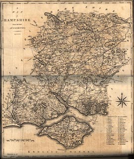
Map, uncoloured engraving, A Map of Hampshire, and the Isle of Wight, scale
about 3 miles to 1 inch, by John Cary, London, 1789.
|
|
Facing vol.1 p.129 in Britannia by William Camden, translated from Latin by
Richard Gough, published London, 1789.
|
|
map feature:-
|
not coloured & compass rose & scale line & lat and long scales &
coast form lines & rivers & relief & hill hachuring & woods
& trees & parks & county & hundreds & table of hundreds
& settlements & roads & distances from London & electoral data
& race courses & castles & harbours |
|
inscription:- |
printed -on- upper left
A / MAP / of / HAMPSHIRE / from the best / AUTHORITIES. / Engraved by J.
Cary.
|
|
scale line:-
|
10 miles = 81.1 mm |
|
dimension:- |
scale = 1 to 200000 ? (1 to 198439 from scale line assuming modern mile) |
|
wxh, map = 43.5x52cm |
 |
|

|
Map Group -- Cary 1789 -- with Research Notes
|
 |
|

| top of page |
| MN: 25.2.2002 |


