|
FA1999.7:-
|
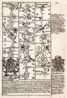
Strip map, road map, two sided sheet taken from a road book, Britannia
Depicta or Ogilby Improv'd, text by John Owen, Middle Temple, London, maps by
Emanuel Bowen, published Thomas Bowles, St Paul's Churchyard, London, 1720
onwards.
|
|
P.73 road through part of Surrey, Liphook, Hampshire, part of West Sussex, then
Petersfield, Horndean, Portsea, to Portsmouth, Hampshire; with the coat of arms
and text for Portsmouth, and text for Portsea Island, Hampshire, and coat of
arms and text for Guildford, Surrey.
|
|
P.74 London through Lewisham, Bromley, Sevenoaks, to Tunbridge, Kent; with text
for Lewisham and coat of arms and text for Tunbridge, Kent.
|
|
map feature:-
|
county & settlements & rivers & woods & relief & hillocks
& bridges & roads & compass rose & coat of arms |
|
dimension:- |
wxh = 13.5x20cm |
 |
|

|
Map Group -- Bowen 1720 -- with Research Notes
|
 |
|
|
town names:-
|
|
Hamp Shire
|
Hampshire
|
|
map name
|
modern name
|
|
Petersfield
|
Petersfield
|
|
Portsmouth
|
Portsmouth
|
|
 |
|

| top of page |
| MN: 4.10.2001 |


