|
FA1999.55:-
|
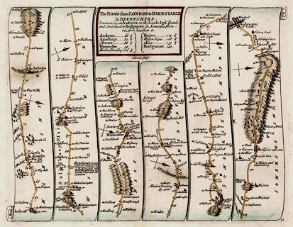
Strip map, road map, hand coloured engraving, scale about 2-2.5 miles to 1
inch, The Road from London to Barnstable, Devon, segment from Andover, Hampshire
to Bridgewater, Somerset from a road book by John Senex, London, 1719.
|
|
From Roads through England Delineated; ... Ogilby's survey revised, improved and
reduced to a size portable for the pocket.
|
|
Pl.32 Andover, Hampshire to Wiltshire border; via Amesbury, Shrewton,
Warminster, Maiden Bradley, Wiltshire; via Wincanton, Bruton, to Bridgewater,
Somerset.
|
|
Note; the plate number is at bottom right, the map is single sided.
|
|
inscription:- |
printed -on- title cartouche
The ROAD from LONDON to BARNSTABLE / in DEVONSHIRE. / Commencing in Andover
in the Land's End Road, / ....
-- title and table of distances |
|
inscription:- |
printed -on- upper centre
I Senex sculpt
|
|
map feature:-
|
title cartouche (plain box, sides curved to fit by scrolls of map) & north
point (simple cross marked with fleur de lys for N and cross for E) & road
distances (miles from Cornhill, London, dot in road, figure beside) & table
of distances & roads (continuous or dotted lines probably indicate fenced or
unfenced?) & settlements (differences in size and typeface of name are
indications of size) & streets (layout in some towns) & rivers &
windmills & parks & woods & forests & relief & hillocks (all
one way up, ie not using a convention for up and down) & county (dotted line
boundary and comment as 'enter Wiltshire') |
|
dimension:- |
wxh, plate = 215x165mm |
|
scale = 1 to 150000 ? (approx) |
 |
|

|
Map Group -- Senex 1719 -- with Research Notes
|
 |
|
|
town names:-
|
|
Hampshire
|
Hampshire
|
|
map name
|
modern name
|
|
Andover
|
Andover
|
|
 |
|

| top of page |
| MN: 4.10.2001 |


