|
FA1999.58:-
|
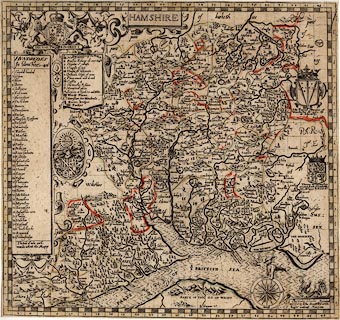
Map, Hamshire ie Hampshire, scale about 4 miles to 1 inch, by John Norden,
about 1595, engraved by Christopher Scwytzer, modified and published by John
Overton, The White Horse, without Newgate, London, about 1670.
|
|
The Old English Miles used by the map maker is 1.24 statute miles.
|
|
The map comes from the Overton Atlas, an untitled compilation of county maps
published in various editions from about 1670-1700; it is described as state III
of Norden's map.
|
|
map feature:-
|
title cartouche & strapwork cartouche & coat of arms & compass rose
& sea monsters & scale of miles (a grid of mile squares over the map)
& table of symbols & sea moire effect & coast shaded & county
& hundreds & table of hundreds & rivers & bridges & relief
& hillocks & beacons & forests & parks & castles &
antiquities & index grid & settlements & mills & windmills &
water mills |
|
inscription:- |
printed -on- lower right
Johes Norden descripsit
-- original? |
|
inscription:- |
printed -on- lower right
Printed / and sold by Iohn Overton at ye white / horse without Newgate
-- added |
|
inscription:- |
printed -on- title cartouche
HAMSHIRE
|
|
scale line:-
|
48 miles = 400.5 mm |
|
dimension:- |
wxh, map = 423x398mm (approx) |
|
scale = 1 to 240000 ? (from town positions using DISTAB.exe) |
 |
|

|
Map Group -- Norden 1595 -- with Research Notes
|
 |
|
|
town names:-
|
|
Hamshire
|
Hampshire
|
|
map name
|
modern name
|
|
alton
|
Alton
|
|
andover
|
Andover
|
|
basingstoke
|
Basingstoke
|
|
bushwaltham
|
Bishops Waltham
|
|
Christ church
|
Christchurch
|
|
fareham
|
Fareham
|
|
fordingbridg
|
Fordingbridge
|
|
gosporte
|
Gosport
|
|
havant
|
Havant
|
|
kingesclere
|
Kingsclere
|
|
lymington
|
Lymington
|
|
alresforde
|
Alresford
|
|
odyam
|
Odiham
|
|
petersfeild
|
Petersfield
|
|
portes mouth
|
Portsmouth
|
|
ringwood
|
Ringwood
|
|
rumsey
|
Romsey
|
|
Southampton
|
Southampton
|
|
stokebridge
|
Stockbridge
|
|
whitchurche
|
Whitchurch
|
|
Winchester
|
Winchester
|
|
 |
|

| top of page |
| MN: 4.10.2001 |


