|
FA1999.59:-
|
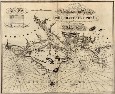
Chart, uncoloured engraving, Spithead, showing the coasts of Hampshire and
the Isle of Wight, by William Heather, engraved by J Stephenson, published by
Heather and Williams, the Navigation Warehouse, 157 Leadenhall Street, London,
1797.
|
|
The chart was published in the East India Pilot, vol.1, as well as being
available separately.
|
|
map feature:-
|
not coloured & scale line & compass rose & magnetic variation &
leading lines & depth soundings & coast dotted & sea marks &
rivers & relief & hill hachuring & table of symbols |
|
inscription:- |
printed -on- upper right
To / The Right Honorable / THE / Master Wardens & Elder Brethren ' of the
Trinity House, / THIS CHART OF SPITHEAD, / Is most Respectfully Dedicated by
their obedient / Servant, / William Heather
|
|
inscription:- |
printed -on- upper right
Engraved by J. Stephenson.
|
|
inscription:- |
printed -on- bottom centre
Published as the Act directs, Decr. 1st. 1797, by, HEATHER and WILLIAMS, at
the Navigation Warehouse, No.157, Leadenhal Street, London.
|
|
dimension:- |
9 sea miles = 130.4 mm = |
|
dimension:- |
wxh, sheet = 80x65cm |
|
wxh, map = 767x622mm (approx) |
|
scale = 1 to 128000 ? (1 to 127965 from scale line assuming a nautical mile is
6082.93 ft) |
 |
|

|
Map Group -- Heather 1797 -- with Research Notes
|
 |
|
|
town names:-
|
|
Hampshire
|
Hampshire
|
|
map name
|
modern name
|
|
Christ Church
|
Christchurch
|
|
Farham
|
Fareham
|
|
Gosport
|
Gosport
|
|
Havant
|
Havant
|
|
Lymington
|
Lymington
|
|
Portsmouth
|
Portsmouth
|
|
Southampton
|
Southampton
|
|
 |
|

| top of page |
| MN: 4.10.2001 |


