|
FA1999.66:-
|
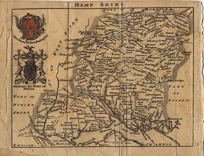
Map, Hamp Shire ie Hampshire, scale about 8 miles to 1 inch, by Samuel
Simpson copied from Moll, published in the Agreeable Historian or Compleat
English Traveller, London, 1746.
|
|
Printed by R Walker, Fleet Lane, London.
|
|
map feature:-
|
coat of arms (Southampton, and the Duke of Bolton) & coast shaded &
rivers & relief & hillocks & forests & parks & county &
hundreds (borders but no names) & settlements & roads (these look like
distances from town to town, or point to point) |
|
inscription:- |
printed -on- top
HAMP SHIRE
|
|
dimension:- |
wxh, sheet = 22.5x17cm |
|
wxh, map = 197x148mm |
|
scale = 1 to 480000 ? (estimate) |
|
longitude, Winchester = 1d 17.2m W (approx) |
 |
|

|
Map Group -- Simpson 1746 -- with Research Notes
|
 |
|
|
town names:-
|
|
Hamp Shire
|
Hampshire
|
|
map name
|
modern name
|
|
Alton
|
Alton
|
|
Andover
|
Andover
|
|
Basingstoke
|
Basingstoke
|
|
Bish. Waltham
|
Bishops Waltham
|
|
Christ Church
|
Christchurch
|
|
Farham
|
Fareham
|
|
Fordingbridg
|
Fordingbridge
|
|
Gosport
|
Gosport
|
|
Havant
|
Havant
|
|
Kingscler
|
Kingsclere
|
|
Lenington
|
Lymington
|
|
Alesford
|
Alresford
|
|
Odiam
|
Odiham
|
|
Petersfield
|
Petersfield
|
|
Portsmouth
|
Portsmouth
|
|
Ringwood
|
Ringwood
|
|
Romsey
|
Romsey
|
|
Southampton
|
Southampton
|
|
Stockbridge
|
Stockbridge
|
|
Whitchurch
|
Whitchurch
|
|
Winchester
|
Winchester
|
|
 |
|

| top of page |
| MN: 4.10.2001 |


