|
FA1999.72.1:-
|
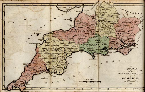
Map, hand coloured engraving, New Map of the Western Circuit of England,
scale about 15 miles to 1 inch, by William Tunnicliff, Salisbury, Wiltshire,
1791.
|
|
In the Survey of the Counties of Hants, Wilts, Dorset, Somerset, Devon, and
Cornwall; ie Hampshire, Wiltshire, etc.
|
|
map feature:-
|
north point & scale line & lat and long scales & time from Greenwich
& coast form lines & county & settlements & roads |
|
scale line:-
|
30 miles = 49.2 mm |
|
inscription:- |
printed -on- lower right
A / NEW MAP / of the / WESTERN CIRCUIT / of / ENGLAND, / by W. Tunnicliff. /
1791.
|
|
dimension:- |
scale = 1 to 980000 ? (1 to 981307 from scale line assuming statute mile) |
|
longitude, Winchester = 1d 24m W (approx) |
 |
|

|
Map Group -- Tunnicliff 1791 -- with Research Notes
|
|
|
 |
|
|
town names:-
|
|
Hampshire
|
Hampshire
|
|
map name
|
modern name
|
|
Alton
|
Alton
|
|
Andover
|
Andover
|
|
Basingstoke
|
Basingstoke
|
|
Bishops Waltham
|
Bishops Waltham
|
|
Christchurch
|
Christchurch
|
|
Fareham
|
Fareham
|
|
Fordingbridge
|
Fordingbridge
|
|
Gosport
|
Gosport
|
|
Havant
|
Havant
|
|
Lymington
|
Lymington
|
|
Alresford
|
Alresford
|
|
Odiham
|
Odiham
|
|
Petersfield
|
Petersfield
|
|
Portsmouth
|
Portsmouth
|
|
Ringwood
|
Ringwood
|
|
Romsey
|
Romsey
|
|
Southampton
|
Southampton
|
|
Stockbridge
|
Stockbridge
|
|
Whitchurch
|
Whitchurch
|
|
Winchester
|
Winchester
|
|
 |
|

| top of page |
| MN: 25.2.2002 |


