|
FA1999.77.1:-
|
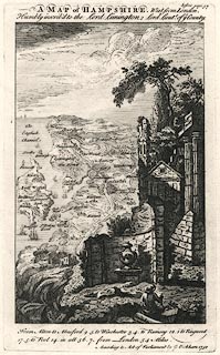
Map, uncoloured engraving, Hampshire, perspective view from the east, by
George Bickham, London, 1750.
|
|
The drawing has a bird's eye view of the county, from somewhere on an imaginary
height above Petersfield, on which a ruin with urn, columns, pyramid and a
seated figure; the map includes Havant to Poole along the coast, with the Isle
of Wight, inland to Alton, Whitchurch, Andover; all is distorted, quite out of
drawing. The 'scale' is about 15 miles to 1 inch.
|
|
map feature:-
|
not coloured & sea shaded & ships & rivers & relief & woods
& forests & settlements & roads & distances from London (printed
below) |
|
inscription:- |
printed -on- top
A MAP of HAMPSHIRE. West from London. / Humbly inscribed to Lord Limington,
Lord Lieut of ye County.
|
|
inscription:- |
printed -on- bottom right
According to Act of Parliament by G. Bickham 1750
|
|
dimension:- |
wxh, plate = 154x254mm |
|
wxh, image = 138x219mm |
|
wxh, page = 202x316mm |
|
scale = 1 to 960000 ? (from town positions using DISTAB.exe) |
 |
|

|
Map Group -- Bickham 1750 -- with Research Notes
|
 |
|
|
town names:-
|
|
Hampshire
|
Hampshire
|
|
map name
|
modern name
|
|
Alton
|
Alton
|
|
Andover
|
Andover
|
|
Waltham
|
Bishops Waltham
|
|
Christ Church
|
Christchurch
|
|
Farham
|
Fareham
|
|
Fording Bridge
|
Fordingbridge
|
|
Havant
|
Havant
|
|
Lymington
|
Lymington
|
|
Alresford
|
Alresford
|
|
Petersfield
|
Petersfield
|
|
Portsmouth
|
Portsmouth
|
|
Ringwood
|
Ringwood
|
|
Rumsey
|
Romsey
|
|
Southhampton
|
Southampton
|
|
Stockbridge
|
Stockbridge
|
|
Whitchurch
|
Whitchurch
|
|
Winchester
|
Winchester
|
|
 |
|

| top of page |
| MN: 4.10.2001 |


