|
FA1999.90:-
|
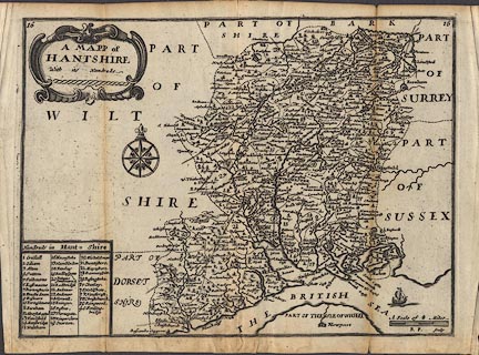
Map, uncoloured engraving, Mapp of Hantshire ie Hampshire, scale about 7.5
miles to 1 inch, by Richard Blome, 1681, engraved by Richard Palmer; edition
published in England Exactly Described, by Thomas Taylor, Golden Lion, Fleet
Street, 1715.
|
|
Plate number 16, engraved top left and right.
|
|
This is one of the earliest maps of Hampshire to show roads; a selection of
those published by John Ogilby, 1675.
|
|
The scale line is very clearly wrong! its '4 miles' is nearer 9.5; the scale of
the map is better estimated from distances between towns. From that the scale
line looks as if it is an 8 mile scale, not 4, the map mile being an Old English
Mile = 1.21 statute miles.
|
|
map feature:-
|
title cartouche & scroll cartouche & table of hundreds & coast
shaded & compass rose & scale line & rivers & relief &
hillocks & forests & trees & parks & county & hundreds &
settlements & roads & fortifications |
|
inscription:- |
printed -on- title cartouche, upper left
A MAPP of / HANTSHIRE / With its Hundreds
|
|
inscription:- |
printed -on- lower right
R P. Sculp
|
|
dimension:- |
scale = 1 to 490000 ? (1 to 489761 from town positions usung DISTTAB.exe) |
 |
|

|
Map Group -- Blome 1681 -- with Research Notes
|
 |
|
|
town names:-
|
|
Hantshire
|
Hampshire
|
|
map name
|
modern name
|
|
Alton
|
Alton
|
|
Andover
|
Andover
|
|
Basingstoke
|
Basingstoke
|
|
Bush Waltham
|
Bishops Waltham
|
|
Christchurch
|
Christchurch
|
|
Fareham
|
Fareham
|
|
Fordingbridge
|
Fordingbridge
|
|
Gosport
|
Gosport
|
|
Havant
|
Havant
|
|
Kingescler
|
Kingsclere
|
|
Lymington
|
Lymington
|
|
Alresford
|
Alresford
|
|
Odyam
|
Odiham
|
|
Petesfeild
|
Petersfield
|
|
Portesmouth
|
Portsmouth
|
|
Ringwood
|
Ringwood
|
|
Rumsey
|
Romsey
|
|
Southampton
|
Southampton
|
|
Stokbridg
|
Stockbridge
|
|
Whitchurch
|
Whitchurch
|
|
Winchester
|
Winchester
|
|
 |
|

| top of page |
| MN: 12.3.2002 |


