|
FA1999.92:-
|
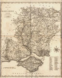
Map, uncoloured engraving, Hampshire, scale about 3 miles to 1 inch, engraved
by John Cary, 1789? published by John Stockdale, Piccadilly, London, 1805.
|
|
map feature:-
|
not coloured & compass rose & scale line & lat and long scales &
coast form lines & harbours & rivers & relief & hill hachuring
& woods & forests & parks & county & hundreds & table of
hundreds & settlements & roads & roman roads &
fortifications |
|
inscription:- |
printed -on- upper left
A / MAP / of / HAMPSHIRE / from the best / AUTHORITIES. / Published by John
Stockdale, Piccadilly, 26th. March 1805. / Engraved by J. Cary.
-- (mispelt name) |
|
scale line:-
|
10 miles = 80.7 mm |
|
dimension:- |
wxh, sheet = 43.5x54.5cm |
|
wxh, map = 431x518mm |
|
scale = 1 to 200000 ? (1 to 199423 from scale line assuming modern mile) |
|
longitude, Winchester = 1d 8.6m W (approx) |
 |
|

|
Map Group -- Cary 1789 -- with Research Notes
|
 |
|

| top of page |
| MN: 4.10.2001 |


