|
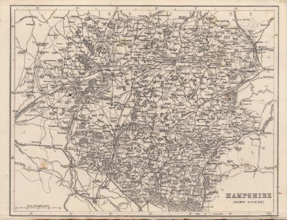
FA1999.104.1:-
|
Map, uncoloured engraving, Hampshire, North Division, scale about 5 miles to
1 inch, by William Hughes, London, 1860s-70s.
|
|
map feature:-
|
not coloured & scale line & rivers & woods & forests & parks
& relief & hill hachuring & county & settlements & roads
& canals & railways & roman roads |
|
inscription:- |
printed -on- lower right
HAMPSHIRE / (NORTH DIVISION)
|
|
inscription:- |
printed -on- bottom right
W. Hughes
|
|
scale line:-
|
8 miles = 40.6 mm |
|
dimension:- |
scale = 1 to 320000 ? (1 to 317112 from scale line assuming modern mile) |
 |
|

|
Map Group -- Hughes 1860s-70s
|
|
|
|
town names:-
|
|
Hampshire
|
Hampshire
|
|
map name
|
modern name
|
|
Alton
|
Alton
|
|
Andover
|
Andover
|
|
Basingstoke
|
Basingstoke
|
|
Bishops Waltham
|
Bishops Waltham
|
|
Kingsclere
|
Kingsclere
|
|
Alresford
|
Alresford
|
|
Odiham
|
Odiham
|
|
Petersfield
|
Petersfield
|
|
Romsey
|
Romsey
|
|
Southampton
|
Southampton
|
|
Stockbridge
|
Stockbridge
|
|
Whitchurch
|
Whitchurch
|
|
Winchester
|
Winchester
|
|
|
|

| top of page |
| MN: 4.10.2001 |