|
FA1999.104.2:-
|
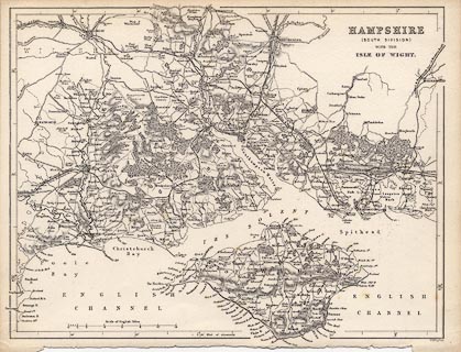
Map, uncoloured engraving, Hampshire, South Division, and the Isle of Wight,
scale about 5 miles to 1 inch, by William Hughes, London, 1860s-70s.
|
|
map feature:-
|
not coloured & scale line & rivers & woods & forests & parks
& relief & hill hachuring & county & settlements & roads
& railways |
|
inscription:- |
printed -on- upper right
HAMPSHIRE / (SOUTH DIVISION) / WITH THE / ISLE OF WIGHT
|
|
inscription:- |
printed -on- bottom right
W. Hughes
|
|
scale line:-
|
12 miles = 61.4 mm |
|
dimension:- |
scale = 1 to 310000 ? (1 to 314529 from scale line assuming modern mile) |
|
longitude, Winchester = 1d 18.4m W (approx) |
 |
|

|
Map Group -- Hughes 1860s-70s
|
|
|
|
town names:-
|
|
Hampshire
|
Hampshire
|
|
map name
|
modern name
|
|
Bishops Waltham
|
Bishops Waltham
|
|
Christchurch
|
Christchurch
|
|
Fareham
|
Fareham
|
|
Fordingbridge
|
Fordingbridge
|
|
Gosport
|
Gosport
|
|
Havant
|
Havant
|
|
Lymington
|
Lymington
|
|
Portsmouth
|
Portsmouth
|
|
Ringwood
|
Ringwood
|
|
Romsey
|
Romsey
|
|
Southampton
|
Southampton
|
|
Stockbridge
|
Stockbridge
|
|
Winchester
|
Winchester
|
|
|
|

| top of page |
| MN: 4.10.2001 |