Map Collection

Moule 1836
FA1999.106.4:- 
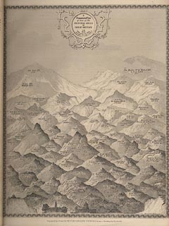
Map, engraving, Comparative View of some of the Principal Hills in Great Britain, drawn by E I Smith, engraved by I Dower, in The English Counties Delineated by Thomas Moule, published by George Virtue, 26 Ivy Lane, Paternoster Row, London, 1839.
The diagram starts from Salisbury Cathedral, St Paul's Cathedral and Greenwich Observatory on its hill as comparisons for hills from Norwood Hill 380ft to Ben Macdui 'the Highest Hill in Great Britain' 4570ft.
inscription:-  printed -on- upper centre A / Comparative View / of some of the / PRINCIPAL HILLS / in / GREAT BRITAIN / A.D. / 1834 / 'Hills peep o'er Hills / and Alps o'er Alps arise.'
dimension:-  wxh, image = 205x255mm

  Map Group -- Moule 1836 -- with Research Notes

  top of page
MN: 25.2.2002