|
FA1999.108:-
|
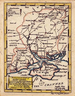
Map, hand coloured engraving, Hamp-Shire ie Hampshire, scale about 14 miles
to 1 inch, by J Cowley, London, 1743.
|
|
map feature:-
|
hand coloured & title cartouche & drape cartouche & compass rose
& scale line & lat and long scales (not rectangular) & coast shaded
(sea coast) & coast form lines (in estuaries) & rivers & forests
(just a few trees in the New Forest) & county & settlements & roads
& road distances & table of symbols |
|
scale line:-
|
10 miles = 18.8 mm |
|
inscription:- |
printed -on- cartouche, lower left
An Improved MAP of / HAMP-SHIRE, / containing ye. Borough & Market / Towns,
with those adjoyning; / also, It's Principal Roads and / Rivers, by I. Cowley /
Geographer to his Majesty.
|
|
dimension:- |
scale = 1 to 860000 ? (1 to 856034 from scale line assuming statute mile) |
|
wxh, map = 130x176mm |
|
wxh, plate = 136x182mm |
|
wxh, page = 16x19cm |
|
longitude, Winchester = 1d 11.3m W (approx) |
 |
|

|
Map Group -- Cowley 1743 -- with Research Notes
|
 |
|
|
town names:-
|
|
Hamp-Shire
|
Hampshire
|
|
map name
|
modern name
|
|
Alton
|
Alton
|
|
Andover
|
Andover
|
|
Bassingstoke
|
Basingstoke
|
|
Bushwaltham
|
Bishops Waltham
|
|
Christ Church
|
Christchurch
|
|
Farham
|
Fareham
|
|
Fordingbridge
|
Fordingbridge
|
|
Gosport
|
Gosport
|
|
Havant
|
Havant
|
|
Kingsclere
|
Kingsclere
|
|
Lymington
|
Lymington
|
|
Allesford
|
Alresford
|
|
Odiam
|
Odiham
|
|
Petersfield
|
Petersfield
|
|
Portsmouth
|
Portsmouth
|
|
Ringwood
|
Ringwood
|
|
Rumsey
|
Romsey
|
|
Southampton
|
Southampton
|
|
Stokebridge
|
Stockbridge
|
|
WhitChurch
|
Whitchurch
|
|
Winchester
|
Winchester
|
|
 |
|

| top of page |
| MN: 4.10.2001 |


