|
FA1999.110.1:-
|
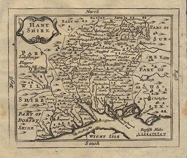
Map, uncoloured engraving, Hant Shire ie Hampshire, scale about 13 miles to 1
inch, by John Seller, London, 1694, published in Camden's Britannia Abridged,
1701.
|
|
The Old English Mile used by the map maker is 1.26 statute miles.
|
|
map feature:-
|
not coloured & title cartouche & scroll cartouche & labelled borders
(North, East, South, West) & scale line & coast shaded & rivers
& relief & hillocks & county & settlements |
|
inscription:- |
printed -on- title cartouche
HANT / SHIRE
|
|
scale line:-
|
10 miles = 24.0 mm |
|
dimension:- |
wxh, map = 146x120mm |
|
wxh, plate = 156x124mm (approx) |
|
wxh, sheet = 18x18.5cm |
|
scale = 1 to 800000 ? (1 to 804672 from scale line assuming modern mile) |
|
scale = 1 to 830000 ? (from town positions using DISTAB.exe) |
 |
|
|
reference:- |
: 1701: Camden's Britannia Abridged: Wild, Joseph (London) |

|
Map Group -- Seller 1694 -- with Research Notes
|
 |
|
|
town names:-
|
|
Hampshire
|
Hampshire
|
|
map name
|
modern name
|
|
Alton
|
Alton
|
|
Andover
|
Andover
|
|
Basingstoke
|
Basingstoke
|
|
Bushwaltham
|
Bishops Waltham
|
|
Christchurch
|
Christchurch
|
|
Farham
|
Fareham
|
|
Kingsclere
|
Kingsclere
|
|
Lymington
|
Lymington
|
|
Alresford
|
Alresford
|
|
Odiam
|
Odiham
|
|
Petersfeild
|
Petersfield
|
|
Portsmouth
|
Portsmouth
|
|
Ringwood
|
Ringwood
|
|
Rumsey
|
Romsey
|
|
Southampton
|
Southampton
|
|
Stockbridge
|
Stockbridge
|
|
Winchester
|
Winchester
|
|
 |
|

| top of page |
| MN: 4.10.2001 |


