|
FA1999.111:-
|
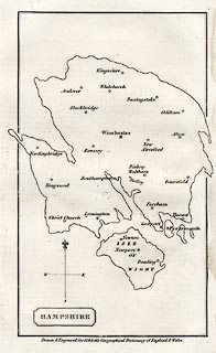
Map, uncoloured engraving, Hampshire, with the Isle of Wight, scale about 12
miles to 1 inch, published in A Geographical Dictionary of England and Wales, by
William Cobbett, Fleet Street, London, 1832.
|
|
The map is curiously distorted, perhaps by an unusual projection?
|
|
map feature:-
|
not coloured & title cartouche & plain cartouche & north point (and
cross line, fl de lys for N, and E S W labelled) & county &
settlements |
|
inscription:- |
printed -on- title cartouche
HAMPSHIRE
|
|
inscription:- |
printed -on- bottom
Drawn & Engraved for Cobbett's Geographical Dictionary of England &
Wales
|
|
dimension:- |
wxh, sheet = 14x22cm |
|
wxh, plate = 12x20 cm (?) |
|
wxh, map (excluding bits overlapping the map border) = 100x173mm |
|
scale = 1 to 780000 ? (from town positions using DISTAB.exe) |
 |
|
|
reference:- |
Cobbett, William: 1832: Geographical Dictionary of England and Wales:
(London) |

|
Map Group -- Cobbett 1832 -- with Research Notes
|
 |
|
|
town names:-
|
|
Hampshire
|
Hampshire
|
|
map name
|
modern name
|
|
Alton
|
Alton
|
|
Andover
|
Andover
|
|
Basingstoke
|
Basingstoke
|
|
Bishop Waltham
|
Bishops Waltham
|
|
Christ Church
|
Christchurch
|
|
Fareham
|
Fareham
|
|
Fordingbridge
|
Fordingbridge
|
|
Gosport
|
Gosport
|
|
Havant
|
Havant
|
|
Kingsclere
|
Kingsclere
|
|
Lymington
|
Lymington
|
|
New Alresford
|
Alresford
|
|
Odiham
|
Odiham
|
|
Petersfield
|
Petersfield
|
|
Portsmouth
|
Portsmouth
|
|
Ringwood
|
Ringwood
|
|
Romsey
|
Romsey
|
|
Southampton
|
Southampton
|
|
Stockbridge
|
Stockbridge
|
|
Whitchurch
|
Whitchurch
|
|
Winchester
|
Winchester
|
|
 |
|

| top of page |
| MN: 4.10.2001 |


