|
FA1999.123.1:-
|
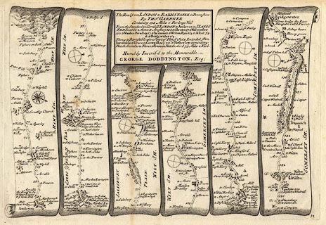
Strip map, road map, uncoloured engraving, part of the Road from London to
Barnstable, Devon, across Hampshire, Wiltshire, Somserset, scale about 2 miles
to 1 inch, reduced from Ogilby's map, 1675, published in a Pocket Guide to the
English Traveller, by Thomas Gardner, London, 1719.
|
|
Pl.32 from Andover via Monxton, Hampshire; Amesbury Shrewton, Warminster, Maiden
Bradley, Wiltshire; Bruton, to Bridgewater, Somerset.
|
|
Amesbury is mislabelled Market Lavington.
|
|
map feature:-
|
not coloured & title cartouche & compass rose & up is destination
& rivers & relief & hillocks & woods & forests & parks
& settlements & inns & roads & distances from London &
streets |
|
inscription:- |
printed -on- title cartouche
The Road from LONDON to BARNSTABLE in devonshire / by THOS. GARDNER / ... /
Humbly Inscrib'd to the Honourable / GEORGE DODDINGTON, Esq;
|
|
wxh, sheet:-
|
33x20.5cm |
|
wxh, plate:-
|
278x188mm |
|
dimension:- |
wxh, map = 276x180mm (?) |
|
scale = 1 to 130000 ? (guess) |
 |
|
|
reference:- |
Gardner, John: 1719: Pocket Guide to the English Traveller: (London) |

|
Map Group -- Gardner 1719 -- with Research Notes
|
 |
|
|
town names:-
|
|
Hamp Sh.
|
Hampshire
|
|
map name
|
modern name
|
|
Andover
|
Andover
|
|
 |
|

| top of page |
| MN: 4.10.2001 |


