|
FA1999.123.3:-
|
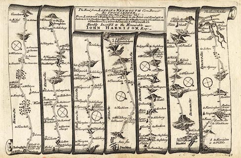
Strip map, road map, uncoloured engraving, part of the Road from London to
Weymouth, Dorset, across Hampshire, Wiltshire, and Dorset, scale about 2 miles
to 1 inch, reduced from Ogilby's map, 1675, published in a Pocket Guide to the
English Traveller, by Thomas Gardner, London, 1719.
|
|
Pl.53 from Basingstoke, via Sutton Scotney, Stockbridge, Romsey, Hampshire, and
Downton, Wiltshire, and Cranborne, Blandford, Dorchester to Weymouth, Dorset.
|
|
map feature:-
|
not coloured & title cartouche & compass rose & up is destination
& rivers & relief & hillocks & woods & forests & parks
& settlements & inns & roads & distances from London &
streets |
|
inscription:- |
printed -on- title cartouche
The Road from LONDON to WEYMOUTH Com Dorset / By THOS. GARDNER. / ... /
Humbly Inscrib'd to the Honourable / JOHN HARRISON, Esq.
|
|
dimension:- |
wxh, sheet = 29x18.5cm |
|
wxh, plate = 274x182mm (?) |
|
wxh, map = 272x172mm (?) |
|
scale = 1 to 130000 ? (guess) |
 |
|
|
reference:- |
Gardner, Thomas: 1719: Pocket Guide to the English Traveller: (London) |

|
Map Group -- Gardner 1719 -- with Research Notes
|
 |
|
|
town names:-
|
|
Hamp Sh.
|
Hampshire
|
|
map name
|
modern name
|
|
Basingstoke
|
Basingstoke
|
|
Stockbridge
|
Stockbridge
|
|
 |
|

| top of page |
| MN: 4.10.2001 |


