|
FA1999.137:-
|
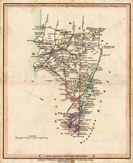
Road map, scale about 8 miles to 1 inch, London to Gosport, Southampton, etc,
Hampshire and Salisbury, etc, Wiltshire on the way to Lands End, from a road
book by Laurie and Whittle, 53 Fleet Street, London, 1806, edition of 1815.
|
|
Pl.5 London; Kingston on Thames, Surrey; Brentford, Staines, Middlesex; Farnham,
Surrey; Alton, New Alresford, Fareham, Gosport, Bishops Waltham, Winchester,
Southampton, Lymington, Romsey, Ringwood, Stockbridge, Ringwood, Fordingbridge,
Basingstoke, Odiham, Kingsclere, Whitchurch, Andover, Hampshire; Salisbury,
market Lavington, Devizes, Wiltshire; Christchurch, Dorset; etc.
|
|
inscription:- |
printed -on- top of map
Commencement of the Road to the Lands End as far as Salisbury with Roads to
Gosport, Southampton, Lymington, Christchurch, Winchester, Ringwood,
E.Lavington, and Devizes.
|
|
scale line:-
|
20 miles = 63.9 mm |
|
inscription:- |
printed -on- bottom of map
ROADS MEASURED FROM HYDE PARK CORNER
|
|
inscription:- |
printed -on- below map
Published 12th. Feby. 1806, by LAURIE & WHITTLE, No. 53, Fleet Street,
London / A New Edition, 1815.
|
|
inscription:- |
printed -on- bottom right
B. Smith sc.
|
|
map feature:-
|
north point & scale line & roads & rivers & settlements &
road distances & county |
|
dimension:- |
wxh, sheet = 26.5x32.5cm |
|
wxh, map = 253x306mm |
|
scale = 1 to 500000 ? (1 to 502707 from scale line assuming statute mile) |
 |
|

|
Map Group -- Laurie and Whittle 1806 -- with Research Notes
|
 |
|
|
town names:-
|
|
Hampshire
|
Hampshire
|
|
map name
|
modern name
|
|
Alton
|
Alton
|
|
Andover
|
Andover
|
|
Basingstoke
|
Basingstoke
|
|
Bishops Waltham
|
Bishops Waltham
|
|
Christ Church
|
Christchurch
|
|
Fareham
|
Fareham
|
|
Fordingbridge
|
Fordingbridge
|
|
Gosport
|
Gosport
|
|
Kingsclere
|
Kingsclere
|
|
Lymington
|
Lymington
|
|
Alresford
|
Alresford
|
|
Odiham
|
Odiham
|
|
Ringwood
|
Ringwood
|
|
Romsey
|
Romsey
|
|
Southampton
|
Southampton
|
|
Stockbridge
|
Stockbridge
|
|
Whitchurch
|
Whitchurch
|
|
Winchester
|
Winchester
|
|
 |
|

| top of page |
| MN: 4.10.2001 |


