|
FA1999.138.25:-
|
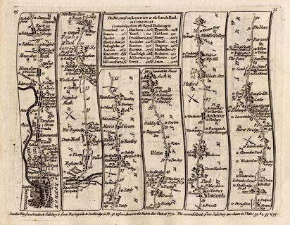
Strip map, road map, uncoloured engraving, Road from London to the Lands End,
in Kitchin's Post Chaise Companion, by Thomas Kitchin, published by Robert
Sayer, 53 Fleet Street, John Bowles, Cornhill, and Carington Bowles, St Paul's
Church Yard, London, 1767.
|
|
Pl.25 London; via Hammersmith, New Brentford, to Staines, Middlesex; via
Bagshot, Surrey; then Blackwater, Hartford Bridge, Basingstoke, Whitchurch,
Andover, to Middle Wallop, Hampshire; on to Salisbury, Wiltshire, and westward;
scale about 3 miles to 1 inch.
|
|
map feature:-
|
not coloured & title cartouche & table of distances & north point
& up is destination & county & settlements & roads & rivers
& distances from London & relief & hillocks & woods &
parks |
|
inscription:- |
printed -on- title cartouche
The ROAD from LONDON to the Lands End, / in CORNWALL. / Containing from the
Royal Exchange to / ....
-- table of distances |
|
dimension:- |
wxh, page = 23x18cm |
|
wxh, plate = 211x162mm (?) |
|
wxh, map = 20x15cm |
|
scale = 1 to 190000 ? (estimated from marked miles as 1 to 176478 assuming
modern mile) |
 |
|

|
Map Group -- Kitchin 1767 -- with Research Notes
|
 |
|
|
town names:-
|
|
Hamp Shire
|
Hampshire
|
|
map name
|
modern name
|
|
Basingstoke
|
Basingstoke
|
|
Whitchurch
|
Whitchurch
|
|
Andover
|
Andover
|
|
 |
|

| top of page |
| MN: 25.2.2002 |


