|
FA1999.140:-
|
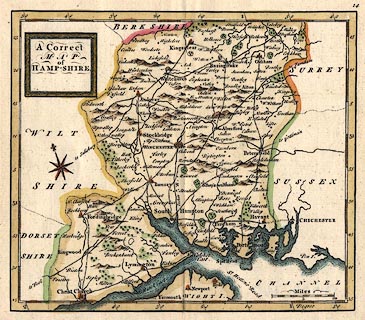
Map, hand coloured engraving, A Correct Map of Hampshire, scale about 9.5
miles to 1 inch, probably by Thomas Hutchinson, 1748, published in Geographia
Magnae Britanniae, 2nd edn, by Osborne et al, London, 1750.
|
|
map feature:-
|
title cartouche & picture frame cartouche & compass rose & lat and
long scales (oblique) & scale line & coast form lines & rivers &
relief & hillocks & forests & parks & county & settlements
& roads |
|
scale line:-
|
10 miles = 29.8 mm |
|
inscription:- |
printed -on- title cartouche
A Correct / MAP / of / HAMP-SHIRE
|
|
dimension:- |
wxh, map = 166x142mm |
|
wxh, sheet = 20x17cm (ie folded page 10x17) |
|
scale = 1 to 540000 ? (1 to 540048 from scale line assuming statute mile) |
|
scale = 1 to 610000 ? (from town positions using DISTAB.exe) |
|
longitude, Winchester = 1d 20.0m W (approx) |
 |
|
|
reference:- |
Hutchinson, Thomas: 1750 (2nd edn): Geographia Magnae Britanniae: Osborne,
Thomas (et al)(London) |

|
Map Group -- Hutchinson 1748 -- with Research Notes
|
 |
|
|
town names:-
|
|
Hamp-Shire
|
Hampshire
|
|
map name
|
modern name
|
|
Alton
|
Alton
|
|
Andover
|
Andover
|
|
Basingstoke
|
Basingstoke
|
|
Bishop's Waltham
|
Bishops Waltham
|
|
Christ Church
|
Christchurch
|
|
Fareham
|
Fareham
|
|
Fordingbridge
|
Fordingbridge
|
|
Gosport
|
Gosport
|
|
Havant
|
Havant
|
|
Kingsclear
|
Kingsclere
|
|
Lymington
|
Lymington
|
|
Alresford
|
Alresford
|
|
Odiham
|
Odiham
|
|
Petersfield
|
Petersfield
|
|
Portsmouth
|
Portsmouth
|
|
Ringwood
|
Ringwood
|
|
Rumsey
|
Romsey
|
|
Sout Hampton
|
Southampton
|
|
Stockbridge
|
Stockbridge
|
|
Whitchurch
|
Whitchurch
|
|
Winchester
|
Winchester
|
|
 |
|

| top of page |
| MN: 4.10.2001 |


