|
B1990.1135.1:-
|
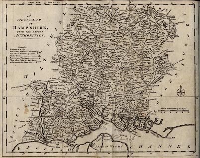
Map, uncoloured engraving, New Map of Hampshire, scale about 5 miles to 1
inch, probably by John Lodge, 1788, published in Collections for the History of
Hampshire, 1795.
|
|
map feature:-
|
not coloured & compass rose & scale line & lat and long scales
(rectangular) & lat and long grid (partial, just the 1 degree west meridian
and the 51 degree north parallel) & coast shaded & rivers & relief
& hillocks & forests & woods & parks & county &
settlements & roads & roman roads & table of symbols &
fairs |
|
scale line:-
|
10 miles = 49.5 mm (statute mile) |
|
inscription:- |
printed -on- upper left
A / NEW MAP / OF / HAMPSHIRE, / FROM THE LATEST / AUTHORITIES.
|
|
dimension:- |
wxh, sheet (trimmed for book) = 37x27cm |
|
wxh, map = 326x258mm |
|
scale = 1 to 330000 ? (1 to 325120 from scale line) |
|
longitude, Winchester = 1d 13.6m W (approx) |
 |
|

|
Map Group -- Lodge 1788 -- with Research Notes
|
 |
|
|
town names:-
|
|
Hampshire
|
Hampshire
|
|
map name
|
modern name
|
|
Alton
|
Alton
|
|
Andover
|
Andover
|
|
Basingstoke
|
Basingstoke
|
|
Bishops Waltham
|
Bishops Waltham
|
|
Christ Church
|
Christchurch
|
|
Fareham
|
Fareham
|
|
Fordingbridge
|
Fordingbridge
|
|
Gosport
|
Gosport
|
|
Havant
|
Havant
|
|
Kingsclere
|
Kingsclere
|
|
Lymington
|
Lymington
|
|
Alresford
|
Alresford
|
|
Odiam
|
Odiham
|
|
Petersfield
|
Petersfield
|
|
Portsmouth
|
Portsmouth
|
|
Ringwood
|
Ringwood
|
|
Rumsey
|
Romsey
|
|
Southampton
|
Southampton
|
|
Stockbridge
|
Stockbridge
|
|
Whitchurch
|
Whitchurch
|
|
Winchester
|
Winchester
|
|
 |
|

| top of page |
| MN: 25.2.2002 |


