|
B1999.518.1778.4.1:-
|
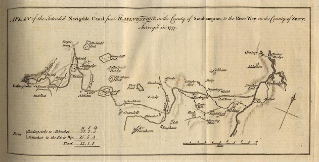
Map, uncoloured engraving, Plan of the intended Navigable Canal from
Basingstoke to the River Wey, scale about 4 miles to 1 inch, about 1777.
|
|
Published in the Gentleman's Magazine, vol.48 1778 April issue between
pp.172-73.
|
|
map feature:-
|
not coloured & canals & scale line & parks & settlements &
streets & north point |
|
scale line:-
|
10 miles = 71.4 mm |
|
inscription:- |
-on-
A PLAN of the intended Navigable Canal from BASINGSTOKE in the County of
Southampton, to the River Wey in the County of Surry; / Surveyed in 1777.
|
|
dimension:- |
wxh, map = 298x142mm |
|
scale = 1 to 230000 ? (1 to 225398 from scale line assuming statute mile) |
 |
|

|
Map Group -- Gent Mag 1770s -- with Research Notes
|
 |
|
|
town names:-
|
|
County of Southampton
|
Hampshire
|
|
map name
|
modern name
|
|
Basingstoke
|
Basingstoke
|
|
 |
|

| top of page |
| MN: 25.2.2002 |


