|
BWM376:-
|
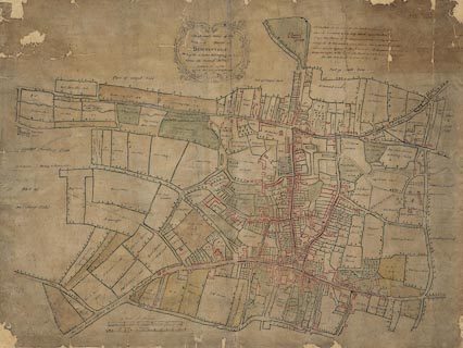
Street map, Town and Manor of Basingstoke, part of the estate of the Duke of
Bolton, Basingstoke, Hampshire, scale about 1 to 1600, 40 inches to 1 mile,
surveyed 1762, copied by Henry Downs, 1836.
|
|
The map shows field names.
|
|
map feature:-
|
title cartouche & scale line & up is N (taken for granted) & rivers
& settlements & streets & roads & field names |
|
scale line:-
|
40+10 perches = 153.0 mm |
|
scale line:-
|
12+1 chains = 164.1 mm |
|
inscription:- |
printed -on- title cartouche
An Accurate Survey of the / Town, and Manor of / BASINGSTOKE. / Part of the
Estates belonging to his / Grace the Duke of Bolton / taken A.D. 1762 / copied
Novr. 1836 By Henry Downs
|
|
dimension:- |
wxh, sheet = 97.5x74.5cm |
|
scale = 1 to 1600 ? (1 to 1593 from scale line of chains) |
 |
|

|
Map Group -- Unknown 1762
|
 |
|

| top of page |
| MN: 4.10.2001 |


