|
BWM469.4.10:-
|
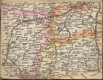
Railway map, hand coloured engraving, railways in Surrey, West and East
Sussex, and Hampshire, scale about 1 to 620000, about 10 miles to 1 inch, p.10
in Bradshaw's Railway Companion, published by Bradshaw and Blacklock, 27 Brown
Street, Manchester, 1841.
|
|
The railway to Hampshire is the London and South Western Railway, which began as
the London and Southampton Railway, opened throughout in 1840, one year before
this guide. The London station is Vauxhall, shown on the London map at the front
of the book. This railway is described on:-
|
|
P.10 (beware the error in page numbering which has the previous page as 10 as
well) map of the LSWR line - through Esher, Weybridge, Woking, Surrey;
Farnborough, Winchfield, Basingstoke, Micheldever, Winchester, to Southampton,
Hampshire.
|
|
The map also shows the Portsmouth Junction Railway as a planned line, this
became the Bishopstoke to Gosport branch railway, opened a year later, 1842.
|
|
Also on the map is the London and Brighton Railway.
|
|
map feature:-
|
rivers & parks & county & settlements & roads & canals &
railways |
|
inscription:- |
printed -on- along the lines
LONDON AND SOUTH WESTERN RAILWAY / PORTSMOUTH JUNCTN.
|
|
dimension:- |
wxh, sheet = 14.5x11.5cm |
|
wxh, map = 146x111mm |
|
scale = 1 to 620000 ? (estimate) |
 |
|

|
Map Group -- Bradshaw 1841 -- with Research Notes
|
 |
|

| top of page |
| MN: 25.2.2002 |


