|
FA1991.24.14:-
|
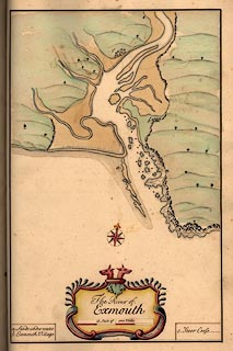
Chart, hand coloured manuscript, The River of Exmouth, Devon, by Edmund
Dummer and Captain Thomas Wiltshaw, Royal Navy, 1698.
|
|
Published in A Survey of the Ports on the South West Coast of England from Dover
to the Lands-end.
|
|
map feature:-
|
hand drawn & title cartouche & compass rose & scale line &
streets & rivers & harbours |
|
inscription:- |
ms -on- drape cartouche
The River of / Exmouth
|
|
scale line:-
|
1 mile = 72.3 mm (what miles?) |
|
dimension:- |
wxh, map = 202x316mm |
|
scale = 1 to 25000 ? (1 to 22259 from scale line assuming a statute mile or 1 to
25644 assuming a sea mile) |
 |
|

|
Map Group -- Dummer 1698 -- with Research Notes
|
 |
|

| top of page |
| MN: 25.2.2002 |


