|
FA2000.7:-
|
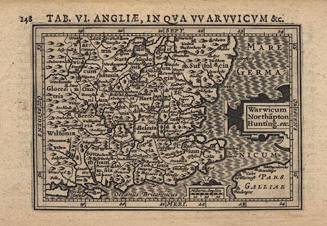
Map, uncoloured engraving, Angliae, in qua Warwicum Etc or Warwicum
Northampton Hunting etc, scale about 45 miles to 1 inch, engraved by Jodocus
Hondius the younger, reduced from the Mercator map of 1595, published by Petrus
Bertius, 1616.
|
|
Includes Warwickshire, Northamptonshire, Huntingdon, Cambridgeshire, Suffolk,
Hertfordshire, Bedfordshire, Buckinghamshire, Oxfordshire, Gloucestershire,
Wiltshire, Berkshire, Middlesex, Essex, Kent, East Sussex, West Sussex, Surrey,
Hampshire, Isle of Wight.
|
|
The Latin text on the reverse describes Yorkshire.
|
|
inscription:- |
printed -on- top
TAB. VI. ENGLIAE, IN QUA WARWICUM &c.
|
|
inscription:- |
printed -on- title cartouche
Warwicum / Northa~pton / Hunting. etc.
|
|
scale line:-
|
30 miles = 17.1 mm |
|
dimension:- |
wxh, sheet = 19.5x11.5cm |
|
wxh, plate = 137x96mm |
|
wxh, map = 135x94mm |
|
longitude, Winchester = 19d 24m E (approx) |
 |
|

|
Map Group -- Bertius 1616 -- with Research Notes
|
 |
|
|
town names:-
|
|
Southamtonia
|
Hampshire
|
|
map name
|
modern name
|
|
Aulton
|
Alton
|
|
Basyngstoke
|
Basingstoke
|
|
Havant
|
Havant
|
|
Kingesclere
|
Kingsclere
|
|
Lemrington
|
Lymington
|
|
Petersfeldt
|
Petersfield
|
|
Southa~ton
|
Southampton
|
|
Winchester
|
Winchester
|
|
 |
|

| top of page |
| MN: 12.7.2002 |


