|
FA2000.10.7:-
|
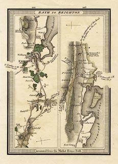
Strip map, road map, part of route Bath, Somerset to Brighton, Sussex, scale
about 1 inch to 1 mile, probably published by E Mogg, London, 1814.
|
|
P.222 from mile 68, via Titchfield, Fareham, via Fareham, to mile 75, and
Portchester, Fareham, Hampshire.
|
|
P.223 from about mile 75 via Portchester, Fareham to mile 80 beyond Cosham,
Portsmouth, Hampshire.
|
|
map feature:-
|
title cartouche & north point & up is destination & coast form lines
& rivers & canals & woods & forests & parks &
settlements & inns & milestones & roads & turnpike roads &
turnpike gates & distances from London & streets |
|
inscription:- |
printed -on- title cartouche at top
BATH TO BRIGHTON
|
|
inscription:- |
printed -on- bottom
measured from the Market House Bath
|
|
dimension:- |
scale = 1 to 65000 ? (estimate) |
 |
|

|
Map Group -- Mogg 1814 -- with Research Notes
|
 |
|

| top of page |
| MN: 4.10.2001 |


