|
FA2000.20.15:-
|
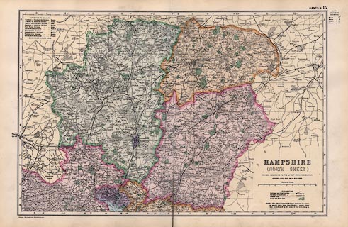
Map, Hampshire North Sheet, scale about 1 to 190000, about 3 miles to 1 inch,
in Bacon's Library Atlas of the British Isles, published by G W Bacon and Co,
Bacon's Geographical Establishment, London, 1907.
|
|
map feature:-
|
lat and long scales & scale line & index grid & table of symbols
& harbours & depth contours & rivers & woods & parks &
relief & hill hachuring & county & settlements & roads &
roman roads & railways & canals & electoral data (divisions and
boroughs) |
|
inscription:- |
printed -on- lower right
HAMPSHIRE / (NORTH SHEET) / REVISED ACCORDING TO THE LATEST ORDNANCE SURVEY
/ DIVIDED INTO FIVE MILE SQUARES
|
|
scale line:-
|
10 miles = 86.3 mm |
|
dimension:- |
wxh, sheet = 53x34.5cm |
|
wxh, map = 466x308mm |
|
scale = 1 to 190000 ? (1 to 186483 from scale line) |
 |
|

|
Map Group -- Bacon 1907
|
 |
|
|
town names:-
|
|
Hampshire
|
Hampshire
|
|
map name
|
modern name
|
|
Alton
|
Alton
|
|
Andover
|
Andover
|
|
Basingstoke
|
Basingstoke
|
|
Bishops Waltham
|
Bishops Waltham
|
|
Kingsclere
|
Kingsclere
|
|
New Alresford
|
Alresford
|
|
Odiham
|
Odiham
|
|
Petersfield
|
Petersfield
|
|
Romsey
|
Romsey
|
|
Southampton
|
Southampton
|
|
Stockbridge
|
Stockbridge
|
|
Whitchurch
|
Whitchurch
|
|
Winchester
|
Winchester
|
|
 |
|

| top of page |
|
| MN: 25.2.2002 |


