|
FA2000.21.2:-
|
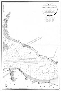
Chart, uncoloured engraving, Chart of Part of the Isle of Wight and the Coast
of Hampshire between Calshot and Gillkicker, scale about 1 to 24000?, about 3ins
to 1 nautical mile, surveyed by Lt Murdoch Mackenzie, 1783, drawn by Besancon,
engraved by Caplin, published by the Depot-general de la Marine, France,
1823.
|
|
map feature:-
|
not coloured & title cartouche & oval cartouche & north point &
magnetic variation & depth soundings (and bottoms) & depth contours
& coast appearance & sea marks & leading lines (with copious
comments) & sandbanks & anchorages & tides (tidal flows) &
rivers & harbours & settlements (on the coast) & castles &
fortifications & salterns |
|
scale line:-
|
7 nautical miles = 551.2 mm |
|
inscription:- |
printed -on- title cartouche
PLAN / D'UNE PARTIE de L'ILE DE WIGHT / et / DE LA COTE DE HAMPSHIRE /
Depuis la Pointe Gillkicker jusqu'an Chateau de Calshot. / Leve en 1783 par le
Lieutenant Murdoch Mackensie. / PUBLIE PAR ORDRE DU ROI / Sous le Ministere de
Son Excellence M. le Marquis DE CLERMONT-TONNERRE / Pair de France, Secretaire
d'Etat au Department de la Marine et des Colonies, / Au Depot-generale de la
Marine / en 1823.
|
|
inscription:- |
printed -on- bottom
Grave par Caplin Ecrit par Besancon PRIX Trois Francs.
|
|
dimension:- |
wxh, sheet = 69x103cm |
|
wxh, plate = 645x965mm |
|
wxh, map = 614x934mm |
|
scale = 1 to 24000 ? (1 to 23546 from scale line assuming english nautical
mile) |
 |
|

|
Map Group -- Mackenzie 1780s -- with Research Notes
|
 |
|

| top of page |
| MN: 4.10.2001 |


