|
FA2000.21.3:-
|
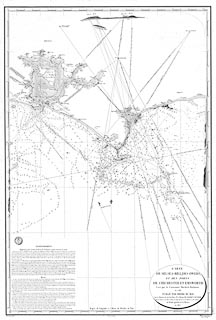
Chart, uncoloured engraving, Chart of Selsea Bill, the Owers, and Chichester
and Emsworth Harbours, scale about 1 to 40000?, about 1 1/2 ins to 1 mile,
surveyed by Lt Murdoch Mackenzie, 1786, drawn by Besancon, engraved by Caplin,
published by the Depot-general de la Marine, France, 1823.
|
|
map feature:-
|
not coloured & title cartouche & oval cartouche & north point &
magnetic variation & lat and long scales & lat and long grid (longitude
west of Paris meridian) & depth soundings (and bottoms) & depth contours
& coast appearance & coast view & sea marks & leading lines
(with copious comments) & sandbanks & anchorages & tides (tidal
flows) & rivers & harbours & relief (elevation view as sea marks)
& settlements (on the coast) & salterns |
|
inscription:- |
printed -on- title cartouche
CARTE / DE SELSEA-BILL, DES OWERS, / ET DES PORTS / DE CHICHESTER ET
EMSWORTH / Leve par le Lieutenant Murdoch Mackensie / en 1786 / PUBLIE PAR ORDRE
DU ROI / Sous le Ministere de Son Excellence M. le Marquis DE CLERMONT-TONNERRE
/ Pair de France, Secretaire d'Etat au Department de la Marine et des Colonies,
/ Au Depot-generale de la Marine / en 1823.
|
|
inscription:- |
printed -on- bottom
Grave par Caplin Ecrit par Besancon PRIX Cinq Francs. / Avec le No. 42(6
2).
|
|
dimension:- |
wxh, sheet = 69x103cm |
|
wxh, plate = 648x972mm |
|
wxh, map = 626x935mm |
|
scale = 1 to 40000 ? (18 mins lat = 82.2mm is 1 to 40726) |
 |
|

|
Map Group -- Mackenzie 1780s -- with Research Notes
|
 |
|

| top of page |
| MN: 4.10.2001 |


