|
FA2000.22:-
|
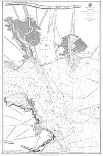
Chart, uncoloured engraving, St Helen's Road, Spithead, Portsmouth and
Langstone Harbours, scale about 1 to 23000?, about 3 ins to 1 nautical mile,
surveyed by Lt Murdoch Mackenzie, 1783, published by the Hydrographical Office,
1808.
|
|
Sold by R B Bate, 21 Poultry, London.
|
|
map feature:-
|
not coloured & compass rose & magnetic variation & scale line &
depth soundings (and bottoms) & depth contours & coast appearance &
sea marks & leading lines & sandbanks & anchorages & tides
(tidal flows) & rivers & harbours & relief & settlements (on the
coast) & castles & fortifications & salterns |
|
scale line:-
|
7 nautical miles = 555.8 mm |
|
inscription:- |
printed -on- upper right
ST. HELEN'S ROAD / SPITHEAD / PORTSMOUTH and LANGSTONE / HARBOURS. /
Surveyed in 1783 / by / Lieut. Murdoch Mackenzie Junr. / ....
|
|
inscription:- |
printed -on- bottom centre
Hydrographical Office Published according to Act of Parliament Octr. 1st.
1808. by Cap. Hurd R.N. Hydrographer to the Admiralty
|
|
inscription:- |
printed -on- bottom (outside the map plate)
Sold by R. B. BATE, 21, Poultry, for the Lords Commissrs. of the Admiralty,
by their Appointment.
|
|
dimension:- |
wxh, sheet = 68.5x101cm |
|
wxh, plate = 641x973mm |
|
wxh, map = 620x965mm |
|
scale = 1 to 23000 ? (1 to 23351 from scale line assuming english nautical
mile) |
 |
|

|
Map Group -- Mackenzie 1780s -- with Research Notes
|
 |
|
|
town names:-
|
|
Gosport
|
Hampshire
|
|
map name
|
modern name
|
|
Gosport
|
Gosport
|
|
Portsmouth
|
Portsmouth
|
|
 |
|

| top of page |
| MN: 4.10.2001 |


