|
FA2000.30.77:-
|
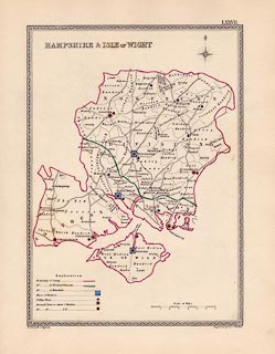
Map, coloured engraving, Hampshire and Isle of Wight, including the
Christchurch area now in Dorset, showing electoral divisions etc, scale ?
miles to 1 inch, drawn by R Creighton, engraved by J and C Walker, published by
Samuel Lewis and Co, 87 Aldersgate Street, London, 1835.
|
|
Plate LXXVII in vol.5 of A Topographical Dictionary of England; notice that
Hampshire in is the alphabetical sequence as Southampton; a detached part of
Hampshire appears on the map for Sussex.
|
|
map feature:-
|
compass rose & scale line & table of symbols & rivers & county
& electoral data & settlements & roads |
|
inscription:- |
printed -on- upper left
HAMPSHIRE & ISLE OF WIGHT
|
|
inscription:- |
printed -on- top right
LXXVII.
|
|
inscription:- |
printed -on- bottom left
Drawn by R. Creighton
|
|
inscription:- |
printed -on- bottom right
Engraved by J&C Walker
|
|
scale line:-
|
7 miles = 52.9 mm this cannot be correct - JMN |
|
dimension:- |
wxh, sheet = 25x32cm |
|
wxh, map = 179x249mm |
|
(scale cannot be deduced from scale line) |
 |
|

|
Map Group -- Lewis 1835 -- with Research Notes
|
 |
|
|
town names:-
|
|
Hampshire
|
Hampshire
|
|
map name
|
modern name
|
|
Alton
|
Alton
|
|
Andover
|
Andover
|
|
Basingstoke
|
Basingstoke
|
|
Bishops Waltham
|
Bishops Waltham
|
|
Christchurch
|
Christchurch
|
|
Fareham
|
Fareham
|
|
Fordingbridge
|
Fordingbridge
|
|
Havant
|
Havant
|
|
Kingsclere
|
Kingsclere
|
|
Lymington
|
Lymington
|
|
New Alresford
|
Alresford
|
|
Odiham
|
Odiham
|
|
Petersfield
|
Petersfield
|
|
Portsmouth
|
Portsmouth
|
|
Ringwood
|
Ringwood
|
|
Romsey
|
Romsey
|
|
Southampton
|
Southampton
|
|
Stockbridge
|
Stockbridge
|
|
Whitchurch
|
Whitchurch
|
|
Winchester
|
Winchester
|
|
 |
|

| top of page |
| MN: 16.6.2002 |


