|
FA2000.40:-
|
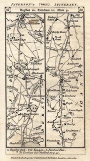
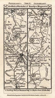
Strip map, road map, uncoloured engraving, part of the road from London to
Winchester and Poole, from vol.1 of the road book, Paterson' British Itinerary,
by Capt Daniel Paterson, published by Carington Bowles, 69 St Paul's Churchyard,
London, 1785.
|
|
Vol.1 p.37/38 via Bagshot, Surrey; then Farnborough, Hampshire; Farnham, Surrey;
past Alton, Hampshire.
|
|
Vol.1 p.39/40 through New Alresford, Winchester, Romsey, to past Ringwood,
Hampshire.
|
|
map feature:-
|
not coloured & up is destination & north point & rivers &
bridges & relief & hill hachuring & forests & parks & county
& settlements & roads & road distances & streets |
|
inscription:- |
printed -on- top, verso
PATERSON'S (VOL.I.) ITINERARY,
|
|
inscription:- |
printed -on- top, recto
DIRECT (VOL.I.) ROADS.
|
|
inscription:- |
printed -on- bottom
Printed for the Proprietor CARINGTON BOWLES, London, 3 Jan. 1785.
|
|
dimension:- |
wxh, sheet = 11x18.5cm |
|
wxh, map = 82x161mm |
 |
|

|
Map Group -- Paterson 1785 -- with Research Notes
|
 |
|

| top of page |
| MN: 4.10.2001 |


