|
FA2000.42:-
|
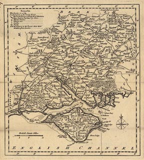
Map, uncoloured engraving, Hampshire, with the Isle of Wight, scale about 1
to 450000, about 7 miles to 1 inch, from the Kitchin's Pocket Atlas, published
by Thomas Kitchin, Holborn Hill, London, 1769.
|
|
map feature:-
|
not coloured & compass rose & lat and long scales & scale line &
table of symbols & sandbanks & coast shaded & rivers & relief
& hillocks & woods & forests & parks & county &
settlements & roads & distances from London |
|
scale line:-
|
12 miles = 42.6 mm |
|
dimension:- |
wxh, sheet = 23x28cm |
|
wxh, plate = 215x240mm |
|
wxh, map = 207x232mm |
|
scale = 1 to 450000 ? (1 to 453336 from scale line assuming modern mile) |
 |
|

|
Map Group -- Kitchin 1769 -- with Research Notes
|
 |
|
|
town names:-
|
|
Hampshire
|
Hampshire
|
|
map name
|
modern name
|
|
Alton
|
Alton
|
|
Andover
|
Andover
|
|
Basingstoke
|
Basingstoke
|
|
Waltham
|
Bishops Waltham
|
|
Christ Church
|
Christchurch
|
|
Farham
|
Fareham
|
|
Fordingbridge
|
Fordingbridge
|
|
Gosport
|
Gosport
|
|
Havant
|
Havant
|
|
Kingsclere
|
Kingsclere
|
|
Lymington
|
Lymington
|
|
Alresford
|
Alresford
|
|
Odiam
|
Odiham
|
|
Petersfield
|
Petersfield
|
|
Portsmouth
|
Portsmouth
|
|
Ringwood
|
Ringwood
|
|
Rumsey
|
Romsey
|
|
Southampton
|
Southampton
|
|
Stockbridge
|
Stockbridge
|
|
Whitchurch
|
Whitchurch
|
|
Winchester
|
Winchester
|
|
 |
|

| top of page |
| MN: 4.10.2001 |


