|
FA2000.45:-
|
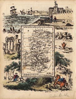
Map, hand coloured lithograph surrounded by vignette scenes, Hampshire, with
the Isle of Wight, scale about 21 miles to 1 inch, published in Reuben Ramble's
Travels through the Counties of England by Darton and Clark, 58 Holborn Hill,
London, 1845.
|
|
The map is distorted; the E-W scale is about 21 miles to 1 inch estimated from
the scale line, the N-S scale about 15 miles to 1 inch estimated from the
latitude scale.
|
|
Originally drawn by R Miller, 24 Old Fish Street, St Paul's, London, 1810.
|
|
The surrounding scenes show the fortifications of Portsmouth Harbour with a
cannon, William Rufus shot by an arrow in the New Forest, Netley Abbey ruins, a
couple of pigs, and ?antiquities found in the county.
|
|
An accompanying text page describes the county.
|
|
map feature:-
|
north point & scale line & lat and long scales & coast shaded &
rivers & forests (some names only) & parks & county &
settlements & roads & railways (projected) & vignettes |
|
inscription:- |
printed -on- title, lower left
HAMPSHIRE
|
|
scale line:-
|
10 miles = 11.9 mm |
|
dimension:- |
wxh, sheet = 16.5x21cm |
|
wxh, map = 70x108mm |
|
scale = 1 to 1400000 ? (1 to 1352390 from scale line assuming modern mile) |
|
scale = 1 to 960000 ? (40 mins lat = 77.1mm is 1 to 962545) |
|
longitude, Winchester = 1d 14.9m W (approx) |
 |
|

|
Map Group -- Ramble 1845 -- with Research Notes
|
 |
|
|
town names:-
|
|
Hampshire
|
Hampshire
|
|
map name
|
modern name
|
|
Alton
|
Alton
|
|
Andover
|
Andover
|
|
Basingstoke
|
Basingstoke
|
|
Bishops Waltham
|
Bishops Waltham
|
|
Christ Church
|
Christchurch
|
|
Fareham
|
Fareham
|
|
Fordingbridge
|
Fordingbridge
|
|
Gosport
|
Gosport
|
|
Havant
|
Havant
|
|
Kingsclere
|
Kingsclere
|
|
Limington
|
Lymington
|
|
Odiham
|
Odiham
|
|
Petersfield
|
Petersfield
|
|
Portsmouth
|
Portsmouth
|
|
Ringwood
|
Ringwood
|
|
Romsey
|
Romsey
|
|
Southampton
|
Southampton
|
|
Stockbridge
|
Stockbridge
|
|
Whitchurch
|
Whitchurch
|
|
Winchester
|
Winchester
|
|
 |
|

| top of page |
| MN: 4.10.2001 |


