|
FA2000.46:-
|
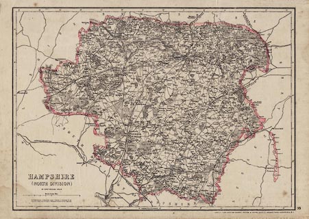
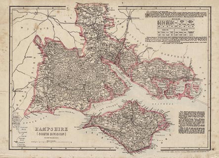
Map, 2 sheet engraving plates 32 and 33, Hampshire, with the Isle of Wight,
scale about 1 to 190000, about 3 miles to 1 inch, by Edward Weller, 1858,
published in Cassell's British Atlas, by Cassell, Petter and Galpin, La Belle
Sauvage Yard, Ludgate Hill, London, 1864-67.
|
|
Originally published in parts and as an atlas by the Weekly Dispatch, 139 Fleet
Street, London, 1858-63.
|
|
map feature:-
|
scale line & lat and long scales (rectangular) & rivers & harbours
& relief & hill hachuring & woods & forests & parks &
county & electoral data & descriptive text (statistics for about
1861-62) & settlements & roads & railways & canals &
fortifications & castles |
|
inscription:- |
printed -on- lower left
HAMPSHIRE / (NORTH DIVISION) / BY EDWD. WELLER F.R.G.S.
|
|
inscription:- |
printed -on- lower left
HAMPSHIRE / (SOUTH DIVISION) / BY EDWD. WELLER F.R.G.S.
|
|
inscription:- |
printed -on- bottom right
LONDON, PUBLISHED BY CASSELL, PETTER & GALPIN, LA BELLE SAUVAGE YARD,
LUDGATE HILL, E.C.
|
|
scale line:-
|
10 miles = 85.4 mm |
|
dimension:- |
wxh, sheet = 49x34cm |
|
wxh, map = 426x305mm |
|
scale = 1 to 190000 ? (1 to 188448 from scale line) |
|
longitude, Winchester = 1d 18.8m W (approx) |
 |
|

|
Map Group -- Dispatch 1863 -- with Research Notes
|
 |
|
|
town names:-
|
|
Hampshire
|
Hampshire
|
|
map name
|
modern name
|
|
Alton
|
Alton
|
|
Andover
|
Andover
|
|
Basingstoke
|
Basingstoke
|
|
Bishops Waltham
|
Bishops Waltham
|
|
Kingsclere
|
Kingsclere
|
|
Alresford
|
Alresford
|
|
Odiham
|
Odiham
|
|
Petersfield
|
Petersfield
|
|
Stockbridge
|
Stockbridge
|
|
Whitchurch
|
Whitchurch
|
|
Winchester
|
Winchester
|
|
|
town names:-
|
|
Hampshire
|
Hampshire
|
|
map name
|
modern name
|
|
Christ-Church
|
Christchurch
|
|
Eastley
|
Eastleigh
|
|
Fareham
|
Fareham
|
|
Fordingbridge
|
Fordingbridge
|
|
Gosport
|
Gosport
|
|
Havant
|
Havant
|
|
Lymington
|
Lymington
|
|
Portsmouth
|
Portsmouth
|
|
Ringwood
|
Ringwood
|
|
Romsey
|
Romsey
|
|
Southampton
|
Southampton
|
|
Stockbridge
|
Stockbridge
|
|
 |
|

| top of page |
| MN: 4.10.2001 |


