|
FA2000.47:-
|
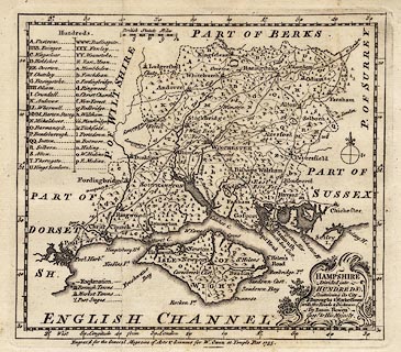
Map, uncoloured engraving, Hampshire Divided into Hundreds, scale about 1 to
640000, about 10 miles to 1 inch, engraved for W Owen for the General Magazine
of Arts and Sciences by Emanuel Bowen, London, 1755, edition of 1758?
|
|
map feature:-
|
not coloured & title cartouche & scroll cartouche & compass rose
& scale line & lat and long scales (rectangular) & coast form lines
& harbours & rivers & relief & hillocks & woods &
forests & parks & county & hundreds & settlements & roads
& road distances |
|
inscription:- |
printed -on- title cartouche
HAMPSHIRE / Divided into / HUNDREDS, / Containing its City / Buroughs &
Market Towns / with the Roads & Distances. / By Eman. Bowen / Geogr. to His
Majesty.
|
|
inscription:- |
printed -on- bottom
Engrav'd for the General Magazine of Arts & Sciences for W. Owen at Temple
Bar 1755.
|
|
scale line:-
|
12 miles = 30.2 mm |
|
dimension:- |
wxh, sheet = 24.5x20cm |
|
wxh, plate = 205x182mm |
|
wxh, map = 197x173mm |
|
scale = 1 to 640000 ? (1 to 639474 from scale line assuming modern mile) |
|
longitude, Winchester = 1d 11.1m W (approx) |
 |
|

|
Map Group -- Bowen 1755 -- with Research Notes
|
 |
|
|
town names:-
|
|
Hampshire
|
Hampshire
|
|
map name
|
modern name
|
|
Alton
|
Alton
|
|
Andover
|
Andover
|
|
Basingstoke
|
Basingstoke
|
|
Bishops Waltham
|
Bishops Waltham
|
|
Christ Church
|
Christchurch
|
|
Farham
|
Fareham
|
|
Fordingbridge
|
Fordingbridge
|
|
Gosport
|
Gosport
|
|
Havant
|
Havant
|
|
Kingsclear
|
Kingsclere
|
|
Lymington
|
Lymington
|
|
Alresford
|
Alresford
|
|
Odiam
|
Odiham
|
|
Petersfield
|
Petersfield
|
|
Portsmouth
|
Portsmouth
|
|
Ringwood
|
Ringwood
|
|
Rumsey
|
Romsey
|
|
Southampton
|
Southampton
|
|
Stockbridge
|
Stockbridge
|
|
Whitchurch
|
Whitchurch
|
|
Winchester
|
Winchester
|
|
 |
|

| top of page |
| MN: 4.10.2001 |


